 |
| 2439 Central Zone of São Paulo |
Posted on 13.04.2013, 06.04.2016
 |
| 0598 Central Zone of São Paulo - Copan Building and Italy Building |
In 1711, the small town received the status of City. Early in the 19th century, after the independence of Brazil, São Paulo became the capital of the province. Practically, the setllement as it shown today was formed during the 20th century, growing from village to metropolis through an irregular urban sprawl. More accurate, until the mid-1950s, in São Paulo the plans were based only on the idea of "demolish and rebuild", the city reaching to have the third highest density of buildings in the world.
 |
| 2438 Central Zone of São Paulo - Vale do Anhangabaú |
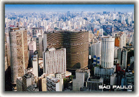
The Central Zone of the city, one of the largest commercial and business districts in Latin America, is bounded officially by districts of Municipality Cathedral, but the social perception of it varies and may include other areas of the city. In the middle of the postcard 0598 can be seen the Edifício Copan (Copan Building), one of the largest buildings in Brazil, with the largest floor area of any residential building in the world, erected between 1957 and 1966.
It wasn't named after the ancient Mayan city, Copan being an acronym for its developer, Companhia Pan-Americana de Hotéis e Turismo. The building was designed by Oscar Niemeyer's office in São Paulo, he himself being responsible for the sinuous facade design. In the left is Edifício Itália, a 168m tall skyscraper (the 2nd tallest building in São Paulo) built between 1956 and 1965 after the plans designed by Franz Heep. It has a rooftop observation deck, open for tourists.
In the postcard 2438 is a panoramic view of Vale do Anhangabaú, considered, along with Sé district, the cradle of São Paulo. At the beginning of its history, São Paulo was comprised of the triangle formed by the Monastery of São Bento, the Monastery of São Francisco, and the Pátio do Colégio. Within this hub was the River Anhangabaú ("bad spirits" in the Tupi-Guarani language), which was buried into the ground in the 18th century. Now the valley itself is a giant boulevard with gardens, sculptures and a view of the main downtown office buildings.
About the stamps
On the postcard 0598
The first stamp, depicting a trumpet, is part of a series of ten, issued in 2002. The following three, depicting a sapateiro (shoe repairman), a manicure (manicurist), respectively a costureira (dressmaker), are part of the series Profissões (Professions), about which I wrote here. The last one, designed by Miriam Guimaraes, was issued on July 13, 2011 and has as subject Carta Social (it hasn't a value on the front).
On the postcard 2438 are the same stamps, without the one with Carta Social.
On the postcard 2439
The second postcard is part of the series Profissões (Professions), about which I wrote here.
References
São Paulo - Wikipedia
Central Zone of São Paulo - Wikipedia
São Paulo/Vale do Anhangabaú - Wikitravel
Sender 0598, 2438: Genesio Wagner (direct swap)
0598: Sent from Parobé (Rio Grande do Sul / Brazil), on 26.11.2012
2438: Sent from Parobé (Rio Grande do Sul / Brazil), on 16.08.2012
Photo: Anizio L. de Miranda
Sender 2439: Simone / Simone_K (postcrossing) BR-387445
2439: Sent from São Paulo (São Paulo / Brazil), on 19.03.2016
Photo: Roberto Caldeiro Stajano / 2000


No comments:
Post a Comment