Lying close to the coast of Eastern Macedonia, Thassos, the northernmost major Greek island, is geographically part of the North Aegean Sea, but administratively belongs to the Kavala regional unit. It is formed mainly by gneisses, schists and marbles of the Rhodope Massif, and is of generally rounded shape. The terrain is mountainous but not particularly rugged, rising gradually from coast to centre. Pine forest covers much of the island's eastern slopes. Thassos is also the name of the largest town (officially known as Limenas Thassou, "Port of Thassos"), situated at the northern side, opposite the mainland and about 10 kilometres from Keramoti.
Historically, the population was engaged in agriculture and stockbreeding, and established villages inland, some of them connected via stairways (known as skalas) to harbors at the shore. The inhabitants migrated towards these shoreline settlements as tourism began to develop as an important source of income. Thus, there are several "paired villages" such as Maries-Skala Maries, with the former inland and the latter on the coast. Thasos's economy relies on timber, marble quarries, olive oil and honey. Tourism has also become important since the 1960s.
The island was inhabited from the Palaeolithic period, but the earliest settlement explored in detail is that at Limenaria, where remains from Neolithic relate closely to those found at the mainland's Drama plain. It was colonised at an early date by Phoenicians. Thasos or Thasus, son of Phoenix, was said to have been their leader, and to have given his name to the island. Around 650 BC, Greeks from Paros founded a colony here. Thasian power, and sources of its wealth, extended to the mainland, where the Thasians owned gold mines even more valuable than those of the island. The wine, nuts and marble of Thasos were also well known in antiquity.
It was important during the Ionian Revolt against Persia. After the defeat of Xerxes the Thasians joined the Delian League; but afterwards they revolted and had several conflicts with the Athenians throughout the 5th century BC. In the embroilment between Philip V of Macedonia and the Romans, Thasos submitted to Philip, but received its freedom at the hands of the Romans after the Battle of Cynoscephalae (197 BC), and it was still a "free" state in the time of Pliny. Since 395 AD it was part of the Byzantine Empire , and remained in Byzantine hands for most of the Middle Ages.
Captured by the Genoese Gattilusi family ca. 1434, it was incorporated into the Ottoman Empire in 1456. A revolt against Ottoman rule arose in 1821, at the outbreak of the Greek War of Independence, led by Hatzigiorgis Metaxas, but it failed. The island had been given in 1813 by the Sultan Mahmud II to Muhammad Ali of Egypt as a personal fiefdom. Egyptian rule was relatively benign and the island became prosperous, until 1908, when the New Turk regime asserted Turkish control. In 1912, during the First Balkan War, a Greek naval detachment freed Thasos from the Ottomans and it became part of Greece. From the day it was reunited with Greece, it has remained so ever since.
About the stamp
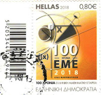
The stamp is part of the series About Anniversaries and Events, designed by Theano Venieri and issued on June 19, 2018.
• the 100th anniversary of the birth of Nikolaos Psaroudakis (0.72 EUR)
• the 100th anniversary of the founding of the Hellenic Mathematical Society (0.80 EUR) - I's on the postcard 3270
• the 25th anniversary of the foundation of the Inter-Parliamentary Assembly on Orthodoxy (0.90 EUR)
References
Thasos - Wikipedia
Sender: Dănuţ Ivănescu
Sent from Limenas Thassou (Thassos / Eastern Macedonia and Thrace / Greece), on 02.08.2019


I envy this postcard. That's what I collect, postcards with maps.
ReplyDelete