Showing posts with label NETHERLANDS (Sint Maarten). Show all posts

October 7, 2017

2425, 2738, 3158 NETHERLANDS (Sint Maarten) - Maho Beach

2425 Sint Maarten - An Air France Airbus over Maho Beach

Posted on 01.04.2016, 05.08.2016, 07.10.2017
The island of Saint Martin is served by many major airlines that daily bring in large jet aircraft, including Boeing 747s and Airbus A340s carrying tourists from across the world. The short main runway at Princess Juliana International Airport, and its position between a large hill and a beach, causes some spectacular approaches. Aviation photographers flock to the airport to capture pictures of large jets just a few metres above sunbathers on Maho Beach.

2738 Sint Maarten - Aircraft over Maho Beach

Located in Sint Maarten, the Dutch side of the island, the Princess Juliana International Airport is the major gateway for the smaller Leeward Islands, including Anguilla, Saba, St. Barthélemy and St. Eustatius. It is named after Juliana of the Netherlands, who as crown princess landed here in 1944, the year after the airport opened. Started as a military airstrip in 1942, it was converted to a civilian airport in 1943. Despite the reputed difficulties in approach, there have been no records of major incidents at the airport.

3158 Sint Maarten - Aircraft over Maho Beach (3D lenticular postcard)

July 29, 2017

1935-1939, 2670, 3115 SAINT MARTIN - The map of the island and the flags of Saint Martin (France) and of Sint Maartin (Netherlands)

1935 The map of Saint Martin Island (1)

Posted on 04.10.2015, 30.07.2016, 29.07.2017
Located in the northeast Caribbean, between Anguilla and Saint Barthélemy, Saint Martin is the smallest inhabited sea island divided between two nations, respectively between France (60%) and the Kingdom of the Netherlands (40%). The southern Dutch part comprises Sint Maarten and is one of four constituent countries that form the Kingdom of the Netherlands, and the northern French part comprises the Collectivité de Saint-Martin and is an overseas collectivity of France.

1936 The map of Saint Martin Island (2)

The main cities are Philipsburg (Dutch side) and Marigot (French side). The Dutch side is more heavily populated, and the largest settlement on the entire island is Lower Prince's Quarter. The highest hilltop is the Pic Paradis (424m) in the center of a hill chain on the French side, but both sides are hilly with large mountain peaks. This forms a valley where many houses are located. There are no rivers on the island, but many dry guts. It has a tropical monsoon climate with a dry season from January to April and a rainy season from August to December.

1937 The map of Saint Martin Island (3)

Ancient relics date the island's first settlers, probably Ciboney Indians (a subgroup of Arawaks), back to 3,500 years ago. Their lives were turned upside-down with the descent of the Carib Indians, a warrior nation which killed the Arawak men and enslaved the women. In 1493 Christopher Columbus glimpsed the island and named it Isla de San Martín after Saint Martin of Tours because it was November 11, St. Martin Day, but Spain made the settlement of the island a low priority.

2670 The map of Saint Martin Island (4)

Instead, the French and Dutch coveted the island. While the French wanted to colonize the islands between Trinidad and Bermuda, the Dutch found San Martín a convenient halfway point between their colonies in New Amsterdam (present day New York) and Brazil. The Dutch, French and British founded settlements on the island. In 1633 Spanish forces captured Saint Martin from the Dutch, but in 1648 they deserted the island. Preferring to avoid an war, the French and Dutch signed in the same year the Treaty of Concordia, which divided the island in two, as it is now.

3115 The map of Saint Martin Island (5)

With the cultivation of cotton, tobacco, and sugar, mass numbers of slaves were imported to work on the plantations, until the slave population became larger than that of the land owners. After abolition of slavery in the first half of the 19th century, plantation culture declined and the island's economy suffered. In 1939, Saint Martin received a major boost when it was declared a duty-free port. The Dutch began focusing on tourism in the 1950s. The French needed another twenty years to start developing their tourism industry.

1938 Saint Martin - The border monument which celebrates
the peaceful coexistence of the French and Dutch on St. Martin (1)

Currently, tourism provides the backbone of the economy for both sides of the island. St. Martin's Dutch side is known for its festive nightlife, beaches, jewellery, drinks made with native rum-based guavaberry liquors, and casinos. The island's French side is known for its nude beaches, clothes, shopping (including outdoor markets), and French and Indian Caribbean cuisine. Because the island is located along the intertropical convergence zone, it is occasionally threatened by tropical storm activity in the late summer and early fall.

1938 Saint Martin - The border monument which celebrates
the peaceful coexistence of the French and Dutch on St. Martin (2)

The culture of Saint Martin is a blend of its African, French, British, and Dutch heritage. Although each side's culture is influenced by their respective administering countries, they share enough similar heritage and traditions that it can be difficult to tell where Saint-Martin ends and Sint Maarten begins. Nowadays, the number of Creoles has been surpassed by the number of immigrants, and the island's population is truly a melting pot of people from 70 or more different countries.

March 27, 2016

2414 NETHERLANDS (Sint Maarten) - The Cupecoy Beach


Located at the Southwest corner of St Maarten, Cupecoy Beach is a small, clothing optional beach lined with beautiful rock formations and caves, and with usually calm waters as it is not exposed to the open Atlantic. It had some "stormy" times in the past decade. Not only development projects, but also Hurricanes and the drifts take their toll changing the face of the beach (and the amount of sand) constantly. Thus it has to get filled up with sand once in a while.

February 25, 2016

2329 NETHERLANDS (Sint Maarten) - The Westin Dawn Beach Resort & Spa


Westin Hotels & Resorts is an upscale hotel chain owned by Starwood Hotels & Resorts Worldwide, which in 2013 operated over 192 hotels. Among them is the one situated on Dawn Beach, along St. Maarten's eastern coast. Located just south of the Dutch/French border, Dawn Beach is famous for two things: the amazing sunrises that earned the shoreline its name, and the clear water that's perfect for snorkeling.

December 13, 2015

2119, 2120 SAINT MARTIN - Young women on the beach


The influence of the French to the north (Saint Martin) and Dutch in the south (Sint Maarten) gives this island a more European feel. As in other Carribean islands, the traditional dress of women in Saint Martin is Madras, which takes its name from the Madras cloth, a lightweight cotton fabric with typically patterned texture and plaid design.


In nowadays, women wear Madras only during cultural dances etc (especially in the French side), because they have shifted to wearing modern dresses. However, Madras cloth remained fairly commonly, as also the head scarf, which can be tied in a ceremonial fashion or can be worn to show the availability of the woman in courtship. Increasingly more is preferred the wide brimmed hat, because it shades also the face.

October 20, 2015

1976 NETHERLANDS (Sint Maarten) - Pointe Blanche


Pointe Blanche is located at the Southeastern tip of Sint Maarten, next to Philipsburg and Great Bay. There is a tiny beach there, and some Pointe Blanche residents go there for a walk, for collecting shells or for surfing. From the top of the hill, there are spectacular views of the cruise ships coming into Great Bay, and leaving the pier, and also to the neighboring islands, such as St. Barths. On the postcard are also the statues of Peter Stuyvesant and Albert Claudiud Wathey.

October 17, 2015

1883-1887, 1965 NETHERLANDS (Sint Maarten) - Philipsburg

1883 Sint Maarten - Philipsburg - The peninsula that separates
the Little Bay and Great Bay


Posted on 10.09.2015, and 17.10.2015
Philipsburg is the main town and capital of Sint Maarten (a constituent country of the Kingdom of the Netherlands, which encompasses the southern 40% of the Caribbean island of Saint Martin, while the northern 60% of the island constitutes the French overseas collectivity of Saint-Martin). The town has about 1,400 inhabitants, and consists of four parallel streets situated on a narrow stretch of land between Great Bay (where the cruise ships dock), and the Great Salt Pond (where salt was made many years ago).

1884 Sint Maarten - Philipsburg - Cruise ships docked

The island was first sighted by Christopher Columbus on 11 November (St. Martin's Day) 1493, but there was already an Arawak settlement there before his "discovery". Philipsburg was founded in 1763 by John Philips, a Scottish captain in the Dutch navy, the settlement soon becoming a bustling centre of international trade, and since 1768 the Dutch capital. Two historic forts bear witness to Philipsburg's strategic importance: Fort Amsterdam (the first Dutch military outpost in the Caribbean) and Fort Willem (built in 1801 by the British).

1885 Sint Maarten - Philipsburg - On the beach
 

Although most of the vessels that arrive in the harbor today are cruise ships (like Celebrity Solstice, Crown Princess, Disney Magic, and since 2010, Oasis of the Seas) international trade still thrives in St. Maarten thanks to its status as a leading duty-free port. In the 1950s, a prominent politician of the Democratic Party, Dr. A.C. Wathey considered that tourism could be one of Sint Maarten's economic pillars he was right. If in 1964 the cruise tourism took off, in 1980 105,000 cruise passengers visited the island, and in 2012 their number reached 1.7 million.

1886 Sint Maarten - Philipsburg - The cruise ship Crown Princess docked

The main shopping district, Front Street, is in the heart of the city, and is lined with duty-free shops offering everything from Italian leather goods and Japanese cameras to native crafts. Over the last few years it was beautified with paving stones, benches, new sidewalks, palm trees, and cast iron streetlights. Actually, the entire area has been improved greatly over the last few years. The harbor was dredged so that cruise ships could tie up at a new terminal. The sand from the dredging was used to replenish Great Bay beach and a boardwalk was built running the length of the beach.

1887 Sint Maarten - Philipsburg

Actually, Front Street has reinvented itself. Now it's mall-like, with a redbrick walk and streets, palm trees lining the sleek boutiques, jewelry stores, souvenir shops, outdoor restaurants, and the old reliables, like McDonald's and Burger King. Here and there a school or a church appears to remind visitors there's more to the island than shopping. Back Street is where you'll find the Philipsburg Market Place. Old Street, near the end of Front Street, has stores, boutiques, and open-air cafés offering French crepes, rich chocolates, and island mementos.

1965 Sint Maarten - Old Street
 

The narrow alleyways (steegjes) which connects the four main streets have Dutch names recalling the street signs in Amsterdam, and lead in either direction to arcades and courtyards filled with flowers. Visitors will also find examples of traditional West Indian architecture, including characteristic pastel-colored houses with second-story verandas looking out over the street. The lacy carvings of the fanciful gingerbread houses often form patterns that could remind the fairy-tale children of the witch's house built of bread and decorated with cakes.

October 7, 2015

1945 NETHERLANDS (Sint Maarten) - Porto Cupecoy


Nestled in a protected cove on Simpson Bay Lagoon, and just across the border from Terres Basses and the French side of the island, Porto Cupecoy is a luxurious, private condominium community built around a seaside piazza, featuring international boutiques, renowned restaurants and a deep water white-glove marina with 54 boat slips. With its Mediterranean village-inspired layout, it blends classic sophistication and Caribbean comfort with modern convenience.

October 2, 2015

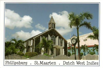
1932 NETHERLANDS (Sint Maarten) - Methodist Church in Philipsburg


Two years after Nathaniel Green, a planter from Antigua, discovered the treatise An Appeal to men of Reason and Religion by John Wesley, he traveled to England and converted to Methodism. He returned to the West Indies in 1759 and began to preach to his slaves in Antigua. In 1786, the Methodist church officially recognized its missionary mission in the Caribbean.