Showing posts with label REALM OF NEW ZEALAND. Show all posts

April 9, 2016

0787, 2449 NEW ZEALAND (South Island) - Te Wahipounamu - South West New Zealand (UNESCO WHS)

0787 Aoraki/Mt Cook

Posted on 09.08.2013, 09.04.2016
Located in the south-west corner of South Island, Te Wähipounamu (Māori for "the place of greenstone") covers 10% of New Zeland's landmass, and exhibits many examples of the tectonic, climatic, and glacial processes that have shaped the earth, but is also the largest and least modified area of New Zealand's natural ecosystems. Inscribed on the World Heritage List in 1990, the site incorporates several national parks: Aoraki/Mt Cook, Fiordland, Mt Aspiring and Westland. A Maori association with the area falls into three broad categories: mythological, traditional history and ethnological. All these values are contained within the tradition of the Ngai Tahu tribe.

2449 Westland Tai Poutini National Park - Franz Josef Glacier and Fox Glacier

As the largest and least modified area of New Zealand's natural ecosystems, the flora and fauna has become the world's best intact modern representation of the ancient biota of Gondwana. The distribution of these plants and animals is inextricably linked to the dynamic nature of the physical processes at work in the property. The region contains outstanding examples of plant succession after glaciation, with sequences along altitudinal (sea level to permanent snowline), latitudinal (wet west to the dry east), and chronological gradients (fresh post-glacial surfaces to old Pleistocene moraines).

2449 Westland Tai Poutini National Park -
Franz Josef Glacier and Fox Glacier (1)

Aoraki/Mount Cook National Park is located near the town of Twizel, and covers over 700km². Glaciers cover 40% of the park area, which houses 19 of the New Zealand's 20 peaks over 3,000m. The mountains of the Southern Alps in general are young, less than ten million years old, and are still building. Aoraki/Mount Cook is the highest mountain in New Zealand (3,754m), and consists of three summits lying slightly south and east of the main divide, the Low Peak, Middle Peak and High Peak, with the Tasman Glacier to the east and the Hooker Glacier to the west.

2449 Westland Tai Poutini National Park -
Franz Josef Glacier and Fox Glacier (2)

According to Māori legend, Aoraki was a young boy who, along with his three brothers, were the sons of Rakinui, the Sky Father. On their voyage around the Papatuanuku, the Earth Mother, their canoe became stranded on a reef and tilted. Aoraki and his brothers climbed onto the top side of their canoe. However, the south wind froze them and turned them to stone. Their canoe became the Te Waka o Aoraki, the South Island. Aoraki, the tallest, became the highest peak, and his brothers created the Kā Tiritiri o te Moana, the Southern Alps. 

2449 Westland Tai Poutini National Park -
Franz Josef Glacier and Fox Glacier (3)

Westland Tai Poutini National Park covers 1,175 km² and extends from the highest peaks of the Southern Alps to a wild and remote coastline, bordering the Aoraki/Mount Cook National Park along the Main Divide. Included in the park are glaciers, scenic lakes and dense temperate rainforest, as well as remains of old gold mining towns along the coast. Franz Josef Glacier (12km long), Fox Glacier (13km long) and a third glacier descends from the Southern Alps to less than 300m above sea level, into temperate rainforest.

February 21, 2016

0295, 2318 NEW ZEALAND - Māori people

0295 A Māori man

Posted on 01.08.2012, 21.02.2016
In 1642, at about 350 years after Māori colonized New Zealand coming from the mythical home Hawaiki in their canoes (waka), Abel Tasman arrived with two ships near to the South Island's shore. Couldn't be said that it was love at first sight. Behold a fragment from the Dutch explorer diary: "Upon this the other natives, with short thick clubs which we at first mistook for heavy blunt parangs [large knives], and with their paddles, fell upon the men in the cock-boat and overcame them by main force, in which fray three of our men were killed and a fourth got mortally wounded through the heavy blows. The quartermaster and two sailors swam to our ship, whence we had sent our pinnace to pick them up, which they got into alive. After this outrageous and detestable crime the murderers sent the cock-boat adrift, having taken one of the dead bodies into their prow and thrown another into the sea."

2318 Māori performing Haka at Whakarewarewa, Rotorua
 

Europeans didn't revisit Nova Zeelandia until 1769, when James Cook mapped almost its entire coastline, anglicised also the name to New Zealand. The route was created, so that the islands have become a stopping and supply point for whaling and trading ships, the sailors developing over time some trade relations with the locals. Besides potato, Māori received diseases unknown for them and muskets, who helped them to be fewer and fewer, the population decreasing to around 40% at the mid of 19th century. Further, Captain William Hobson brought them in 1840 the British sovereignty. Also the Christianity. Although tensions have continued, some Māori have contributed actively to the life of British Empire, even putting his fighting spirit in the crown service in WWI and WWII.

July 13, 2015

1605, 1738 COOK ISLANDS (Atiu) - Land of the birds

1605 Aerial view of Atiu Island

Posted on 24.05.2015, 13.07.2015
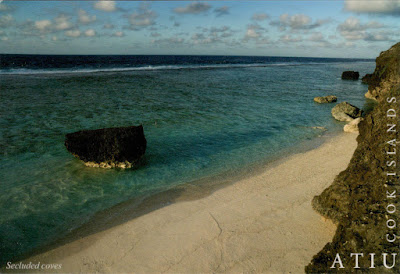
Atiu, also known as Enuamanu (meaning land of the birds), is an island 187 km northeast of Rarotonga, in the Southern Islands group of the Cook Islands. It is a raised volcanic island surrounded by a reef from which rise 6m high cliffs of fossilized coral (makatea), which forms a mile-wide ring round the island, creating a virtual plateau. Erosion at the innerside of the ring has formed dip of about 30m into fertile land, which gradually rises again to a central 70m high flat-topped hill. In common with most islands in the southern group, Atiu has only a small, shallow lagoon. Notched into the cliffs of makatea are over 28 beaches untouched and almost unvisited except by those seeking a beautiful, quiet, and secluded spot.

1738 A secluded cove on Atiu Island

In 2003, the population of Atiu was 571, in five villages radiating out from the island's centre, giving the appearance of a human figure. Atiuans trace their ancestry from Tangaroa, the principal god of Atiu and universally recognised in Polynesia as tutelary God of the Sea. The Atiuans were a fierce, warrior people and before the arrival of the missionaries busied themselves with making war on their neighbors on Mauke and Mitiaro, slaughtering and eating significant numbers of them. Atiu's area is about half that of Rarotonga. The low swampy land consists of taro plantations, marshes and a lake, Te Roto. This fertile area also grows bananas, citrus fruits, pawpaws, breadfruit and coconuts. Atiu has also a long history of growing coffee. The islands' ariki (high chiefs) controlled the land used for planting and received most of the returns.

May 29, 2015

1616 COOK ISLANDS (Atiu) - Ziona CICC Church


The first organised religion established on Atiu, in 1823, was that of the London Missionary Society. In later years, its name changed to Cook Islands Christian Church (CICC) and is the largest religious denomination in this archipelago. Early missionaries and other visitors to Atiu commented on the prominence of Atiu's first church building, erected soon after embracing Christianity, which could be seen from the sea when approaching the island.

May 14, 2015

1493, 1579 COOK ISLANDS (Aitutaki) - The jewel of the Cook Islands

1493 Cook Island - Aerial view of Aitatuki

Posted on 22.03.2015, 14.05.2015
Aitutaki is one of the Cook Islands, an island country in the South Pacific Ocean in free association with New Zealand. Located north of the island of Rarotonga, the archipelago's main population centre, Aitutaki is an "almost atoll" with a maximum elevation of 123m (the hill Maunga Pu), and has a population of approximately 2,000. The barrier reef that forms its basis is roughly the shape of an equilateral triangle with sides of 12km. The southern edge is almost totally below the surface of the ocean, and the eastern side is composed of a string of small islands. The western side contains many of Aitutaki's important features, including a boat passage through the barrier reef allowing for anchorage close to shore at Arutanga. To the north is the bulk of the main island, with a fertile volcanic soil.

1579 Cook Island - One Foor Island (Tapuaetai) Aitatuki

Polynesians probably first settled Aitutaki around AD 900. The first known European contact was with Captain Bligh and the crew of the HMS Bounty when they discovered it on April 11, 1789, prior to the infamous mutiny. In 1942 New Zealand and American forces were stationed on the island, building the two-way airstrip that can be seen today. Aitutaki is famous for its turquoise central lagoon, uninhabited islands and palm-fringed beaches. Another advantage is that until now it has been spared by mass tourism. In 1972, Aitutaki established a separate postal service, and has issued its own stamps (mostly printed by Heraclio Fournier in Spain) since then. Tapuaetai (One Foot Island), a small islet in the south-east of the lagoon, is often said to be the most important attraction, and it is regarded as providing the visitor with the best views of the Aitutaki lagoon.

April 13, 2015

1525 COOK ISLANDS (Roratonga) - Te Rua Manga


With a population of 10,572, Rarotonga is the most populous island of the Cook Islands, an island country in the South Pacific Ocean in free association with New Zealand. Captain John Dibbs, master of the colonial brig Endeavour, is credited as the European discoverer on 25 August 1823, while transporting the missionary Rev. John Williams. The chief town, Avarua, on the north coast, is the capital of the Cook Islands. It is a very popular tourist destination with many resorts, hotels and motels. It is 32km in circumference, and is surrounded by a lagoon. The interior of the island is dominated by eroded volcanic peaks cloaked in dense vegetation.

October 13, 2014

1296 NEW ZEALAND (North Island) - Waihi, the Heart of Gold


Located in the Coromandel Peninsula, one of the great gold mining districts of the world, Waihi is a little settlement (4,503 inhabitants at the 2006 census) notable even for its history as a gold mine town. The township grew around the mining operations since the discovery of gold in 1878, and was a major centre of union unrest in New Zealand during the early years of the 20th century. Mining stopped in 1952 after a total of 160 km of tunnels had been driven into the quartz of Martha Hill, not because the Martha had run out of gold, but rather because of fixed gold prices, lack of manpower, and increasing costs. Mining in the Coromandel Peninsula had otherwise ceased by the 1980s. However, mining later resumed, with some protests against it during the 1987 consent process. As of 2009, the mine comprises about 25-30% of the local economy.

January 20, 2014

0975 NEW ZEALAND - The map and the flag of the country


Located in the southwestern Pacific Ocean, at 1,500km east of Australia, New Zealand (Aotearoa in Māori) comprises two main landmasses - the North Island (Te Ika-a-Māui) and the South Island (Te Waipounamu) - and numerous smaller islands. Is long and narrow, and has a mild and temperate maritime climate. The South Island is divided along its length by the Southern Alps, and the east side of the island is home to the Canterbury Plains, while the West Coast is famous for its rough coastlines such as Fiordland, and Fox and Franz Josef Glaciers. The North Island is less mountainous but is marked by volcanism. The highly active Taupo Volcanic Zone has formed a large volcanic plateau, punctuated by the island's highest mountain, Mount Ruapehu, and host of the country's largest lake, Lake Taupo, nestled in a caldera. The country owes the varied topography to its position straddling the Pacific and Indo-Australian Plates. Actually it's part of Zealandia, a microcontinent that gradually submerged, after breaking away from the Gondwanan supercontinent. During its long isolation (80 million years), it developed a distinctive biodiversity of animal, fungal and plant life, most notable being the large number of unique bird species.

September 25, 2013

0816 NEW ZEALAND (South Island) - Church of the Good Shepherd


Situated on the shores of Lake Tekapo, in the South Island of New Zealand, amongst the natural beauty of the lake and the mountains, the Church of the Good Shepherd was the first church built in the Mackenzie Basin. The foundation stone was laid by H.R.H. the Duke of Gloucester, on January 15th, 1935, and the completed church was dedicated by the Bishop of Christchurch on August 3rd, 1935. Designed by Christchurch architect R.S.D. Harman (1896-1953), and based on sketches by a local artist, Esther Hope (1885-1975), it is arguably one of the most photographed in New Zealand, and features an altar window that frames stunning views of the lake and mountains.

August 13, 2013

0793 NEW ZEALAND (North Island) - Tongariro National Park - Mount Ruapehu (UNESCO WHS)


In 1993 Tongariro National Park became the first property to be inscribed on the World Heritage List under the revised criteria describing cultural landscapes. The mountains at the heart of the park have cultural and religious significance for the Maori people and symbolize the spiritual links between this community and its environment. The park has active and extinct volcanoes, a diverse range of ecosystems and some spectacular landscapes. The park includes many towns around its boundary, and has in the centre the active volcanic mountains Ruapehu, Ngauruhoe, and Tongariro.

July 25, 2013

0767 NEW ZEALAND (South Island) - Moeraki Boulders


The Moeraki Boulders are unusually large and spherical boulders lying along Koekohe Beach, at a place named Kumara, midway between Hampden and Moeraki townships in North Otago. According to Maori legend, the origin of the boulders dates from the loss of the Arai-te-uru, one of the large sailing canoes that came from Hawaiki. On her quest south for the precious greenstone, the canoe was wrecked near Shag Point (Matakaea). The reef which today extends seawards is the canoe's petrified hull, while close by, in the shape of a prominent rock, stands the petrified body of her commander. Strewn along the beach are the boulders which represent the eel baskets, calabashes, and kumaras washed ashore from the wreck. The name Moeraki (Moerangi) means "drowsy day".

June 26, 2012

0260 NEW ZEALAND (South Island) - A hotel for goldseekers


Are two ways to drive between Queenstown (a major centre for snow sports) and Wanaka (the gateway to Mount Aspiring National Park), and the most memorable is Crown Range Road (the one from the picture), the highest paved road in New Zealand (1,121m), with 2m higher than the Desert Road. The road zigzags up to the Crown Terrace (a large flat and fertile area) and from there you can look down to Arrowtown in the Arrow Valley, and across to the Remarkables Range.

March 5, 2012

0137 NEW ZEALAND - Sheep farming


The first European who reached New Zealand was Abel Tasman in 1642, but the islands weren't visited again until 1769, when James Cook mapped almost the entire coastline. Captain Cook was also the one who brought the first sheep in New Zealand, in 1773, 41 years before that the first Christian missionary to set foot on the shores of the North Island. Wool was New Zealand’s major agricultural export during the late 19th century, and even in 1960s it made up over a third of all export revenues. Since then, its price has steadily dropped relative to other commodities and wool is no longer profitable for many farmers. Thereby the sheep population decreased from 70 million in 1982 to about 32 million in today, which mean that however the number of sheep in New Zealand is 8 times greater than the number of inhabitants.