August 31, 2015

1177-1179, 1253-1254, 1861-1864 UNITED NATIONS - The Headquarters in New York City

1861 Headquarters of the United Nations in New York
seen from Roosevelt Island

Posted on 12.08.2014, 28.09.2014, 31.08.2015
The UN Headquarters is situated in the Turtle Bay neighborhood of Manhattan, New York City, on spacious grounds overlooking the East River, and enjoys extraterritoriality. The complex was constructed in stages with the core complex completed between 1948 and 1952. Rather than hold a competition for the design of the facilities for the headquarters, the UN decided to commission a multinational team of leading architects to collaborate on the design.


1177 Headquarters of the United Nations in New York
at sunset
 

The American architect Wallace K. Harrison was named as Director of Planning, and a Board of Design Consultants was composed of architects, planners and engineers nominated by member governments. The board consisted of N. D. Bassov of the Soviet Union, Gaston Brunfaut (Belgium), Ernest Cormier (Canada), Le Corbusier (France), Liang Seu-cheng (China), Sven Markelius (Sweden), Oscar Niemeyer (Brazil), Howard Robertson (United Kingdom), G. A. Soilleux (Australia), and Julio Vilamajó (Uruguay).


1178 The United Nations General Assembly building

The diminutive site on the East River necessitated a "Rockefeller Center"-type vertical complex, thus, it was a given that the Secretariat would be housed in a tall office tower. During daily meetings from February to June 1947, the collaborative team produced at least 45 designs and variations. After much discussion, Harrison, who coordinated the meetings, determined that a design based on Niemeyer's project 32 and Le Corbusier's project 23 would be developed for the final project.

1862 Flags of the member states, arranged in alphabetical order
in front of Headquarters of the United Nations
 

Le Corbusier's project 23 consisted of a large block containing both the Assembly Hall and the Council Chambers near the centre of the site with the Secretariat tower emerging as a slab from the south. Niemeyer's plan was closer to that actually constructed, with a distinctive General Assembly building, a long low horizontal block housing the other meeting rooms, and a tall tower for the Secretariat. Le Corbusier and Niemeyer merged their schemes 23–32, and this, along with suggestions from the other members of the Board of Design Consultants, was developed into project 42G.

1179 Balconies overlooking the main public entrance of the
General Assembly Building at United Nations Headquarters

The complex includes a number of major buildings. While the Secretariat building (154m) is most predominantly featured in depictions of the headquarters, it also includes the domed General Assembly building, the Dag Hammarskjöld Library, as well as the Conference and Visitors Center, which is situated between the General Assembly and Secretariat buildings, and can be seen only from FDR Drive or the East River.

1863 Water fountain in front of the Headquarters of the United Nations
 

Just inside the perimeter fence of the complex stands a line of flagpoles where the flags of all 193 UN member states, plus the UN flag, are flown in English alphabetical order. The UN' system is based on five principal organs: the General Assembly, the Security Council, the Economic and Social Council (ECOSOC), the Secretariat, and the International Court of Justice. The first four are located at the main UN Headquarters in New York City.


1253 Human Rights Day Celebrated
at United Nations Headquarters 1952
 

The General Assembly is the main deliberative assembly of the UN. Composed of all UN members states, the assembly meets in regular yearly sessions, but emergency sessions can also be called. The General Assembly Hall is the largest room in the UN, with seating capacity for over 1,800 people. The design of the room was a collaborative effort by the team of 11 architects that designed Headquarters, and it contains no gift from any Member State.

1864 Snowy Weather at United Nations Headquarters
 

The only gift is anonymous: two abstract murals on each side of the Hall - designed by the French artist Fernand Leger. In the postcard is the celebration of the Human Rights Day at UN Headquarters in 1952. Addressing a full session of the General Assembly on the fourth annual celebration of Human Rights Day, the President of the Assembly, Lester B. Pearson of Canada, expresses his gratitude to all nations for what has been done "towards achieving a greater respect for fundamental human rights".


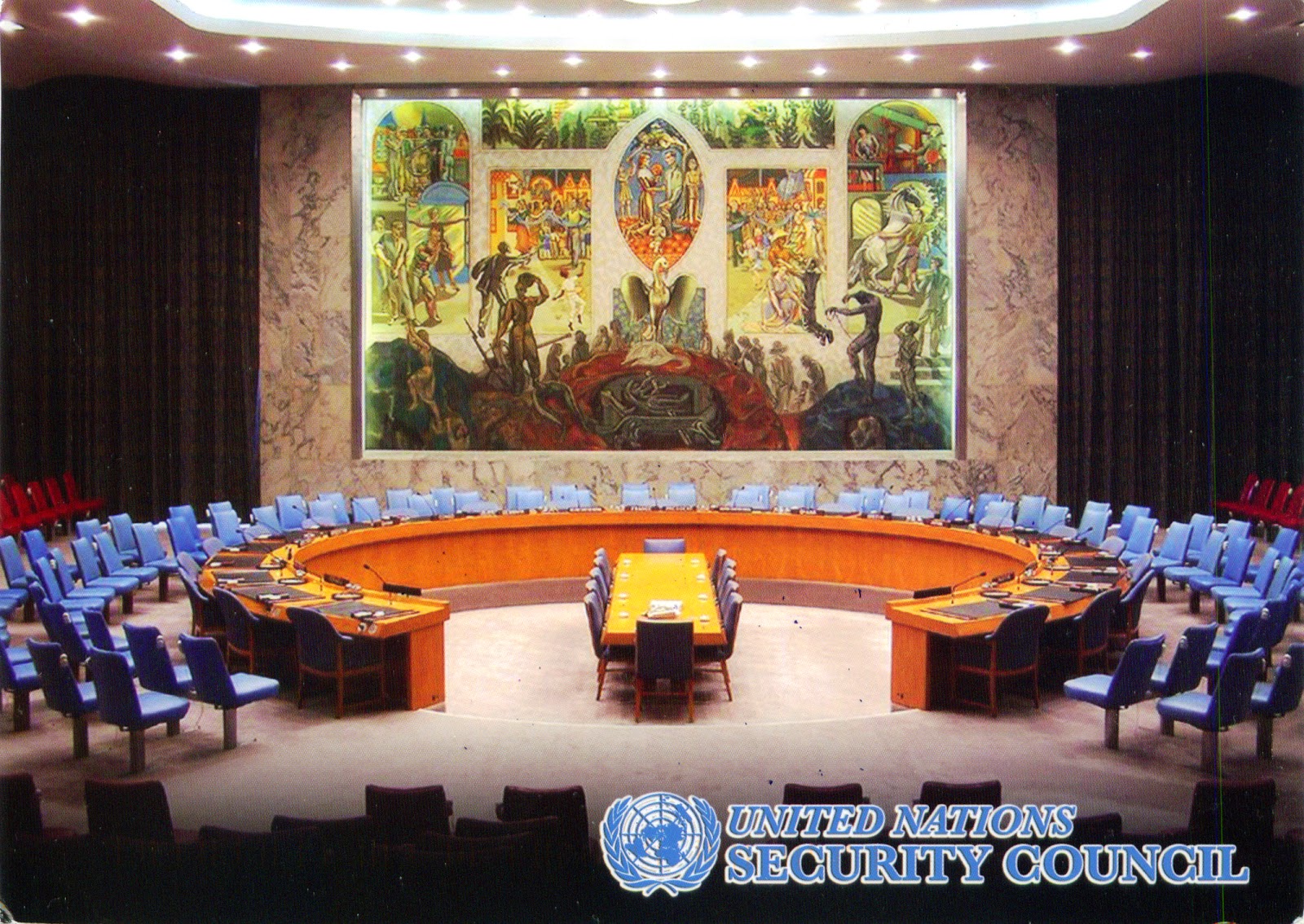
1254 United Nations Security Council

The Security Council is charged with maintaining peace and security among countries, and is made up of 15 member states, consisting of 5 permanent members (China, France, Russia, the United Kingdom, and the United States), and 10 non-permanent members (for two-year terms). The Security Council Chamber was a gift from Norway, designed by the Norwegian architect Arnstein Arneberg. A central feature is the oil canvas mural painted by the Norwegian artist Per Krogh. It depicts a phoenix rising from its ashes, as a symbol of the world being rebuilt after the WWI. Above the dark sinister colours at the bottom different images in bright colours symbolizing the hope for a better future are depicted. Equality is symbolized by a group of people weighing out grain for all to share. The blue and gold silk tapestry on the walls and in the draperies by the East River windows features the anchor of faith, the growing wheat of hope, and the heart of charity.

August 30, 2015

1860 TAIWAN - Alishan Forest Railway


The Alishan Forest Railway is an 86km network of 762mm narrow gauge railways running up to and throughout the popular mountain resort of Alishan in Chiayi County. Originally constructed by the Japanese Colonial Government in 1912 to facilitate the logging of cypress and Taiwania wood, is itself a tourist attraction with unique Z-shaped switchbacks, 50 tunnels, and over 77 wooden bridges. In the 1980s, 10 Hitachi-built diesel-hydraulic locomotives were delivered and replaced the railcars and the steam engines. The railway line was severely damaged by rains associated with 2009's Typhoon Morakot and, as of 2014, services are only running between Chiayi and Fenchihu.

1859 RUSSIA (Stavropol Krai) - Caucasians Dancing Lezginka in Pyatigorsk in 1936


The North Caucasus region is the part of Russia that slopes up towards the main ridge of the Caucasus Mountains, often considered the border between Europe and Asia. It is home to dozens of nationalities and languages, many of which have troubled relationships with their neighbours or with central governments in Moscow or Tbilisi. Nevertheless, all these nationalities have many things in common, especially regarding the traditions. The traditional costume over this region is so similar that it is not unusual to see the exact same photograph presented as being from different ethnicities in the region.

1431, 1858 UNITED KINGDOM (Bermuda) - Somerset Bridge

1431 Somerset Bridge

Posted on31.01.2015, 30.08.2015
Somerset Island is one of the main islands of the chain that makes up Bermuda, and lies in the far west of the territory. The village of Somerset lies in the northern part of the island, which is connected to Boaz Island in the northeast and the Bermudian mainland in the south by bridges. One of these bridges is Somerset Bridge, the smallest working drawbridge in the world. On a series of Bermuda pound banknotes issued from 2009, the bridge is featured on the reverse of the pink five pound note.

1858 Aerial view of Somerset Bridge

The original bridge was built in 1620, and much of its structure remained, although the bridge was largely rebuilt in the mid 20th century. The original bridge was cranked open by hand, whereas the current bridge consists of two cantilevered half-spans, separated by an 46cm gap bridged by a thick timber panel. The entire width of the drawbridge measures 81cm. The panel is removed whenever a yacht wishes to pass beneath the bridge, allowing the unstayed mast to pass through the gap. A captain must wait for a passer-by to assist in opening the drawbridge.

August 28, 2015

1857 MONGOLIA - The Nine Base White Banners


The state banner flown by the Mongols, the "Yöson Khölt tsagaan tug" or the "Nine Base White Banners", is composed of nine flag poles decorated with the tail hair of 1000 white stallions from all over the country, hanging from a round surface with a flame or trident-like shape on the top. It was a peacetime emblem used exclusively by the Khans in front of their yurt, while a black banner was for wartime. The central banner is larger in size than the rest and is placed in the center of the other eight. The modern Mongolian Nine White banners are kept in the Government Palace in Ulaanbaatar.

1856 RUSSIA (Republic of Mordovia) - The Railway Station in Saransk


Located in the Volga basin at the confluence of the Saranka and Insar Rivers, about 630km east of Moscow, Saransk is the capital city of the Republic of Mordovia. Founded in 1641 as the Russian fortress Atemar (at the time, located on the southeastern frontier of Russia), now it accounts for 34.3% of the total population of the republic, that means about 300,000 inhabitants. Trains from Moscow to Ruzaevka was opened to traffic in 1893, and in 1903, in the summer, was completed rail line from Ruzaevka to Nizhny Novgorod, through Saransk.

1855 ROMANIA (Braşov) - A street in Criţ


Mentioned for the first time in 1270 and named for hundreds of years Cruce (German: Kreuz), both names meaning The Cross, because it appears that the settlement formed around a large cross thrust into a promontory, Criţ is a village in the Târnavelor Plateau, at a few km from Viscri. Like any Transylvanian Saxon village is systematized after a staunch geometric line with parallel and perpendicular streets (a spinal layout, not grid-like). What is considered today Transylvanian Saxon architecture actually dates back from the 17th century, when the wooden houses were replaced by stone houses, much less exposed to fire.

August 26, 2015

1854 BELIZE - The Garifuna village of Hopkins


To distinguish the descendants of Caribs Indians and Black African slaves from the Caribs who had not intermarried with Africans, the British colonial administration of then British Honduras named on the first Black Carib and Garifuna, and the last ones Yellow and Red Carib. For a long time, all the black communities living on the Caribbean coast of Central America are commonly called Garifuna. They speak the Garifuna language, a member of the Arawakan languages family albeit an atypical one, containing an unusually high number of loanwords from European languages. The Garifuna language was declared a Masterpiece of the Oral and Intangible Heritage of Humanity in 2008 along with Garifuna music and dance (here).

1853 ITALY (Lombardy) - Teatro alla Scala in Milan


La Scala (abbreviation for Teatro alla Scala) is a famous opera house in Milan, inaugurated on 3 August 1778, and originally known as the New Royal-Ducal Theatre alla Scala (Nuovo Regio Ducale Teatro alla Scala). The premiere performance was Antonio Salieri's Europa riconosciuta. Today, the theatre is still recognised as one of the leading opera and ballet theatres in the world. La Scala's season traditionally opens on 7 December, Saint Ambrose's Day, the feast day of Milan's patron saint. All performances must end before midnight, and long operas start earlier in the evening when necessary.

1852 UNITED KINGDOM (England) - The map of Cornwall


Cornwall is a ceremonial county of England, located in a peninsula bordered by the Celtic Sea, the English Channel, and the county of Devon, over the River Tamar. It has a population of 536,000, its administrative centre, and only city in Cornwall, being Truro, although the town of St Austell has the largest population. The Duchy of Cornwall is one of two royal duchies in England, the other being the Duchy of Lancaster. The eldest son of the reigning British monarch inherits possession of the duchy and title of Duke of Cornwall. The current duke is Prince Charles, the Prince of Wales.

August 25, 2015

1850 UNITED KINGDOM (Cayman Islands) - Brac Reef Beach on Cayman Brac


Cayman Brac is one of the three islands which forms Cayman Islands, named after this prominent feature, as "brac" is a Gaelic name for a bluff. Located on the South Shore of Cayman Brac with 300m of beautiful white sand beach, Brac Reef Beach Resort is an intimate, casual 40-room property catering to divers and snorkelers. The resorts' deluxe beach view rooms have attractive tropical decor.

August 24, 2015

1849 DOMINICAN REPUBLIC - A boy on his donkey


Even if Dominican Republic is the largest economy in the Caribbean and Central American region, a lot of the population lives away from towns, in what is commonly referred to as “el campo” or the country. Here most people live in typical houses made mostly of palm wood, or more commonly now, half concrete half wood. Here people mostly grow “viveres” which refers to root vegetables. Of course, meat also makes up a large portion of the nutrition, and so the care taking of farm animals takes up a large portion of the day.

1533, 1848 KAZAKHSTAN - Petroglyphs within the Archaeological Landscape of Tamgaly (UNESCO WHS)

1533 Petroglyphs of Tamgaly (1)

Posted on 22.04.2015, 24.08.2015
Set around the lush Tamgaly Gorge, amidst the vast, arid Chu-Ili mountains, Tamgaly (which in Kazakh means "painted or marked place") is a remarkable concentration of some 5,000 petroglyphs dating from the second half of the second millennium BC to the beginning of the 20th century. The majority are in the main canyon, but there are a number in the many side canyons, distributed among 48 complexes with associated settlements and burial grounds. They are testimonies to the husbandry, social organization and rituals of pastoral peoples. A huge number of ancient tombs are also to be found including stone enclosures with boxes and cists (middle and late Bronze Age), and mounds (kurgans) of stone and earth (early Iron Age to the present).

1848 Petroglyphs of Tamgaly (2)

The delineation of the property into a sacred core and outer residential periphery, combined with sacred images of sun-heads, altars, and enclosed cult areas, provide a unique assembly. Petroglyphs on unsheltered rock faces, which have been formed using a picketing technique with stone or metal tools, are the most abundant monuments on the property. By far the most exceptional engravings come from the earliest period and are characterized by large figures deeply cut in a sharp way with a wide repertoires of images including unique forms such as solar deities, zoomorphic beings dressed in furs, syncretic subjects, disguised people, and a wide range of animals.

1847 ROMANIA (Sibiu) - Mălâncrav fortified church


The history of Mălâncrav fortified church, as also of the commune, is related to the Apafi family, upper class noble landowners from Transylvania . Because it was a latifundium placed in the midst of the Transylvanian Saxon Seats of Schassburg (Sighişoara), Mediasch (Mediaş) and Grossschenk (Cincu), it was assigned by the Hungarian king to the Apafi family. The first acknowledgment of Mălâncrav (German: Malmkrog) dates from the 14th century in a series of documents related to some disputes over property, which will continue until the 18th century.

August 23, 2015

1846 FRANCE (French Guiana) - Hmong young girls from Cacao


Even if French Guiana has only 250,000 inhabitants, its ethnic diversity is outstanding. The main Asian communities are the Chinese and Hmong people from Laos. The Hmong are an ethnic group from the mountainous regions of  China, Vietnam, Laos, and Thailand. In Laos, many Hmong fought against the invading North Vietnamese Army and the Communist Pathet Lao in the Kingdom of Laos during the Vietnam War. Following Communist victory in 1975, many Hmong were killed or were send in labor camps, so those who could, fled to Thailand or resettled in Western countries, including French Guiana.