Showing posts with label UNESCO World Heritage Sites. Show all posts

March 18, 2020

3461 BRAZIL (Pernambuco) - Brazilian Atlantic Islands: Fernando de Noronha and Atol das Rocas Reserves (UNESCO WHS)

3461 Fernando de Noronha island.

Of indescribable beauty, the Fernando de Noronha Marine National Park, located at a distance of about 340 km off the Brazilian coast, is formed by volcanic peaks of a submerged mountain chain. Nearly 70% of the main island of Fernando de Noronha, 21 smaller islands and islets of the archipelago, as well as most adjacent waters to a depth of 50 metres are part of the property.  The Atol das Rocas Biological Reserve, the only atoll in the South Atlantic, is located about 150 km west of Fernando de Noronha. It is an elliptical reef including two small islands surrounded by a marine reserve.

March 6, 2020

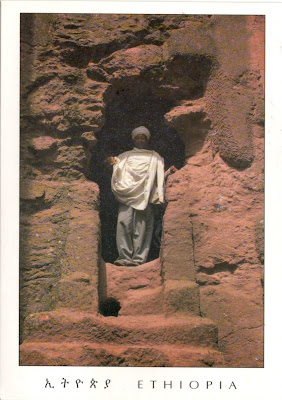
3450 ETHIOPIA (Amhara) - Tomb of Adam - part of Rock-Hewn Churches, Lalibela (UNESCO WHS)

part of Rock-Hewn Churches, Lalibela (UNESCO WHS)

Impressive in its simplicity, the Tomb of Adam is a huge square block of stone stands in a deep trench in front of the western face of Biete Golgotha Mikael (House of Golgotha Mikael). The block has been hollowed out, the ground floor serving as the western entrance to the first group of churches. The upper floor houses a hermit's cell. Again it is a cross that is the only decoration of this "tomb ". The large opening in the eastern wall provides light for the cell and has the shape of a harmonious croix pattee with flat-pitched finials.

February 26, 2020

0134, 3439 SPAIN (Catalonia) - Casa Batlló - part of Works of Antoni Gaudí (UNESCO WHS)

part of Works of Antoni Gaudi (UNESCO WHS)
0134

Part of the Manzana de la Discordia (Block of Discord, but also Apple of Discord), located at 43, Passeig de Gràcia,  in the Eixample district of Barcelona, Casa Batlló is a building restored in the years 1904-1906 by Antoni Gaudí and Josep Maria Jujol (with the contribution of Gaudí's assistants, Domènec Sugrañes i Gras, Josep Canaleta and Joan Rubió). Like all the buildings designed by the brilliant Catalan architect, it looks stunning and very modern, even for today's viewer, so it's hard to imagine how strange it may seem, with its organic, even visceral forms, for the early 20th century Barcelonians.

3439

The building consists of a ground floor, a main floor with a courtyard, four further self-contained floors, a loft and a roof terrace. There is private access to the noble floor (the main floor), and a communal stairwell set within the building well, which has been expanded and artistically tiled as though it were part of the exterior facade. The entire building is astonishing, but stand out in the first place the ground floor (with its tracery, irregular oval windows and flowing sculpted stone work) and the arched roof like a back of a dragon or dinosaur, plated with tiles in the form of scales.

February 23, 2020

3434 ETHIOPIA (Harari) - Harar Jugol, the Fortified Historic Town (UNESCO WHS)

3434 Duke's Gate in Harar Jugol

The walled city Harar functioned as the capital of the Harari Kingdom from 1520 to 1568, became an independent emirate in the 17th century and was integrated into Ethiopian Empire in 1887. From the late 16th century to the 19th century Harar was an important trade centre between the coast and the interior highlands and a location for Islamic learning. The impact of African and Islamic traditions on the development of the town's building types and urban layout make for its particular character and uniqueness.

February 21, 2020

3431 ETHIOPIA (Oromia / Afar) - Lower Valley of the Awash (UNESCO WHS)


The course of the Awash River is entirely contained within the boundaries of Ethiopia and empties into a chain of interconnected lakes that begin with Lake Gargori and end with Lake Abbe on the border with Djibouti. The Awash valley contains one of the most important groupings of palaeontological sites on the African continent. The remains found at the site, the oldest of which date back at least 4 million years, provide evidence of human evolution which has modified our conception of the history of humankind.

February 2, 2020

0346, 2027, 2227, 2513, 3396, 3412 CANADA (Alberta) / UNITED STATES (Montana) - Waterton-Glacier International Peace Park (UNESCO WHS)

3396 Waterton-Glacier International Peace Park


The Waterton-Glacier International Peace Park is the union of the Waterton Lakes National Park in Canada and the Glacier National Park in the United States. Situated on the border between the two countries and offering outstanding scenery, the park is exceptionally rich in plant and mammal species as well as prairie, forest, and alpine and glacial features. It has a distinctive climate, physiographic setting, mountain-prairie interface, and tri-ocean hydrographical divide.

2027 CANADA - Waterton Lakes National Park -
Prince of Wales Hotel on the shore of Waterton Lake

Waterton Lakes National Park was named after Waterton Lake, in turn after the Victorian naturalist and conservationist Charles Waterton. The park contains 505 km2 of rugged mountains and wilderness, and ranges in elevation from 1,290m at the townsite to 2,910m at Mount Blakiston. Overlooked by the historic Prince of Wales Hotel, Waterton Lake is composed of two bodies of water, connected by a shallow channel known locally as the Bosporus.

2227 CANADA - Waterton Lakes National Park - Crypt Lake

Crypt Lake is a pristine alpine lake occupying a cirque that often has ice into August. Most of the area around the lake is covered in scree and/or snow, and hiking around the circumference of the lake requires approximately 45 minutes. The Crypt Lake Trail is one of the premium hikes in park. Wildlife can be spotted in the mountains towering above including mountain goat and bighorn sheep. The slopes along the Crypt Lake Trail serve as primary bear country. From Crypt Lake it is only a short walk to the edge of Crypt Falls with views over the valley below.

2513 CANADA - Waterton Lakes National Park - Cameron Falls

Located in Montana, Glacier National Park includes parts of three sub-ranges of the Rocky Mountains (Clark, Lewis, and Livingston Range), with at least 150 named mountain peaks over 2,400 m, over 130 named lakes (from a total of 700), more than 1,000 different species of plants and hundreds of species of animals. Of the estimated 150 glaciers which existed in the park in the mid-19th century, only 25 active glaciers remained by 2010, and is estimated that all the glaciers may disappear by 2020 if the current climate patterns persist.

0346 UNITED STATES - Glacier National Park -
Clements Mountain

Clements Mountain (2670m), located in the Lewis Range, which stands tall over Logan Pass and above the Hidden Lake Trail. The peak was named after Walter M. Clements who had worked to set up a treaty between the Native American tribe Blackfeet and the U.S. Government for the purchase of tribal lands east of the continental divide which became part of the park.

3412

Today, Blackfeet Indian Reservation borders the park in the east. Like other peaks in Glacier National Park, Clement Mountain exhibits a classic "Matterhorn" shape. Foreground is dominated by a plateau covered with a species of monkey-flowers, perhaps Lewis' monkeyflower (Mimulus lewisii), which is native to western North America, from Alaska to California and Colorado.

January 24, 2020

3390 CZECH REPUBLIC (Vysočina) - Jewish Quarter and St. Procopius' Basilica in Třebíč (UNESCO WHS)


The historical treasury of Třebíč, a town located in western Moravia, on the Jihlava River, includes the old Jewish Quarter (former ghetto) the Jewish Cemetery and the large Romanesque St Procopius' Basilica, which incorporates some later Gothic features, including a rare example of a ten-part (also known as 'botanical') rose window. The ensemble provides an exceptional testimony to the peaceful coexistence of Jewish and Christian communities and cultures from the Middle Ages up to WWII.

January 13, 2020

3354 UNITED KINGDOM (Scotland) - Scott Monument - part of Old and New Towns of Edinburgh (UNESCO WHS)


Placed in Princes Street Gardens in New Town, opposite the Jenners department store on Princes Street, the Scott Monument is a Victorian Gothic monument to famous Scottish author Sir Walter Scott (1771 - 1832), designed by George Meikle Kemp and inaugurated in 1846. Sitting proudly at the base of the monument is Sir Walter himself, carved in Carrara marble by Sir John Steell. This monumental statue, fashioned from a single piece of marble weighing 30 tons, took the sculptor six years to complete. It features Scott and his beloved hound Maida.

January 12, 2020

3353 SLOVAKIA (Prešov) - Bardejov Town Conservation Reserve (UNESCO WHS)


Located in north-eastern Slovakia, on a floodplain terrace of the river Topľa near the Polish border, Bardejov is a small but exceptionally complete and well-preserved example of a fortified medieval town, which typifies the urbanisation in this region. Due to its proximity to the major trade route that stretches across the Carpathian Mountains, from Hungary into Poland, Bardejov was able to develop into an important medieval town. Among other remarkable features, it also contains a small Jewish quarter around a fine 18th-century synagogue.

January 10, 2020

2868, 3345 CZECH REPUBLIC (Prague) - Charles Bridge - part of the Historic Centre of Prague (UNESCO WHS)

3345 Charles Bridge and city skyline in the morning

Charles Bridge is an historic bridge that crosses the Vltava river in Prague. It is 621m long and nearly 10m wide, following the example of the Stone Bridge in Regensburg, and was built as a bow bridge with 16 arches shielded by ice guards. Protected by three bridge towers, it is decorated by a continuous alley of 30 statues and statuaries, originally erected between 1683 and 1714. They depict various saints and patron saints venerated at that time. Beginning in 1965, all of the statues have been systematically replaced by replicas.

2868 Charles Bridge and city skyline on sunset

The construction of the bridge started in 1357 under the auspices of King Charles IV, and finished in the beginning of the 15th century. It  replaced the old Judith Bridge built 1158-1172 that had been badly damaged by a flood in 1342. This new bridge was originally called Stone Bridge or Prague Bridge but has been Charles Bridge since 1870. As the only means of crossing the river Vltava (Moldau) until 1841, it was the most important connection between Prague Castle and the city's Old Town and adjacent areas.

January 9, 2020

3341 ROMANIA (Braşov) - Prejmer fortified church - part of Villages with Fortified Churches in Transylvania (UNESCO WHS)


Located in Burzenland, Prejmer fortified church was initially Roman Catholic, but became Lutheran following the Reformation. Around 1211, King Andrew II of Hungary permitted the Germanic Teutonic Knights to settle around Prejmer, where they began constructing a church in 1218, in Gothic style. They were responsible for the Greek cross plan, the only one of its kind in Transylvania, but found in a few churches in northeast Germany. Following their expulsion in 1225, the Cistercians, who took over in 1240, finished the church.

January 3, 2020

0555-0557, 3319, 3327 BULGARIA (Burgas) - Ancient City of Nessebar (UNESCO WHS)

3319 The Ancient City of Nessebar

Posted on 15.03.2013, 31.12.2019, 03.01.2020
For miles, the road from Varna to Nessebar creeps like a snake along the coast, through the forests where coniferous and deciduous mix like the ethnic groups in the Balkans. But that's not what saw with three millennia ago the Thracians, who came from inland to built the settlement named Menebria, neither the Greeks, who came from the sea to lay the foundations of the prosperous colony named Mesembria. In 71 BC the town fell under Roman rule, yet continued to enjoy privileges, and from the 5th century AD onwards had become one of the most important strongholds of the Byzantine Empire.

0555 A bird's-eye view of the Ancient City of Nessebar

In the following centuries it passed several times from the hands of the Byzantines in those of the Bulgarians, and even of the Crusaders in 1366. The Bulgarian version of the name, Nesebar or Mesebar, has been attested since the 11th century. Conquered by the Ottomans in the same year as Constantinople (1453), it gradually declined until returned to Bulgaria in 1885, becoming since the beginning of the 20th century a key Bulgarian seaside resort.

3327 Vernacular wooden houses in Nessebar
 

As an "outstanding testimony of multilayered cultural and historical heritage", a place where many civilizations left their tangible traces, from the Dorians Black Sea colony's structures to the churches from the Middle Ages and the vernacular wooden houses built in the 19th century, Nessebar was included on the list of UNESCO WHS under the name Ancient City of Nessebar. It is sometimes said to be the town with the highest number of churches per capita, because a total of forty churches had survive, wholly or partly, in the vicinity of the town. Its ancient part is situated on a little peninsula, previously an island, linked with the mainland with only a relatively narrow passageway.

0556 The Church of Christ Pantocrator in Nessebar

One of them is the Church of Christ Pantocrator, constructed in the 13th-14th century and best known for its exterior decoration, rich and colourful. Designed in late Byzantine cross-in-square style, was builded from stones and brickwork, a construction technique known as opus mixtum. The best-known feature of the Church of Christ Pantocrator is the rich and colourful decoration of its exterior walls. Used today as art gallery, is among Bulgaria's best preserved churches of the Middle Ages.

0557 The windmill on the passageway from New Nessebar to Old Nessebar

The Old Windmill shown in the third postcard, located on the passageway from New Nessebar to Old Nessebar, is a lovely, very intact Black Sea style wildmill. Aren't known too much about it, but it's supposed that was built in the Bulgarian revival period from the 17th to the 19th century. The building have a rough style, the design being entirely functional. The windmill base reveals a wooden guiderail and direct wood-to-wood contact.

December 29, 2019

3316 ITALY (Basilicata) - The Sassi and the Park of the Rupestrian Churches of Matera (UNESCO WHS)

3316 View of Sasso Caveoso in Matera, from the Murge

Lying in a small canyon carved out by the Gravina River, Matera is known as la città sotterranea (the underground city), because its historical centre Sassi contains a complex of houses, churches, monasteries and hermitages built into the natural caves of the Murgia. This remarkable and intact troglodyte settlement contains more than a thousand dwellings and a large number of shops and workshops. The morphology of the territory, characterized by deep ravines (gravine) and bare highland plateaus, integrated with ancient cave churches, shepherd tracks marked by wells, and fortified farmhouses, form one of the most evocative landscapes of the Mediterranean.

December 28, 2019

3312 ISRAEL (Jerusalem) - Via Dolorosa - part of The Old City of Jerusalem and its Walls (UNESCO WHS)


Via Dolorosa (Sorrowful Way‎) is a processional route in the Old City of Jerusalem, believed to be the path that Jesus walked on the way to his crucifixion. The winding route from the former Antonia Fortress to the Church of the Holy Sepulchre - a distance of about 600 metres - is a celebrated place of Christian pilgrimage. The current route has been established since the 18th century, replacing various earlier versions. It is today marked by nine Stations of the Cross; there have been fourteen stations since the late 15th century, with the remaining five stations being inside the Church of the Holy Sepulchre.