 |
| 1605 Aerial view of Atiu Island |
Posted on 24.05.2015, 13.07.2015
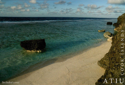
Atiu, also known as Enuamanu (meaning land of the birds), is an island 187 km northeast of Rarotonga, in the Southern Islands group of the Cook Islands. It is a raised volcanic island surrounded by a reef from which rise 6m high cliffs of fossilized coral (makatea), which forms a mile-wide ring round the island, creating a virtual plateau. Erosion at the innerside of the ring has formed dip of about 30m into fertile land, which gradually rises again to a central 70m high flat-topped hill. In common with most islands in the southern group, Atiu has only a small, shallow lagoon. Notched into the cliffs of makatea are over 28 beaches untouched and almost unvisited except by those seeking a beautiful, quiet, and secluded spot.
 |
| 1738 A secluded cove on Atiu Island |
In 2003, the population of Atiu was 571, in five villages radiating out from the island's centre, giving the appearance of a human figure. Atiuans trace their ancestry from Tangaroa, the principal god of Atiu and universally recognised in Polynesia as tutelary God of the Sea. The Atiuans were a fierce, warrior people and before the arrival of the missionaries busied themselves with making war on their neighbors on Mauke and Mitiaro, slaughtering and eating significant numbers of them. Atiu's area is about half that of Rarotonga. The low swampy land consists of taro plantations, marshes and a lake, Te Roto. This fertile area also grows bananas, citrus fruits, pawpaws, breadfruit and coconuts. Atiu has also a long history of growing coffee. The islands' ariki (high chiefs) controlled the land used for planting and received most of the returns.
About the stamp
The stamp, depicting Nymphaea Capensis, is part of a series of nine, Resized Flower, issued on 2013.
References
Atiu - Wikipedia
Sender 1605, 1738:
Sent from Atiu (Atiu / Cook Islands), on 15.04.2015


No comments:
Post a Comment