September 20, 2013

0666, 0810, 0811 GREECE (Attica) - Acropolis of Athens (UNESCO WHS)


Posted on 03.06.2013 and completed on 20.09.2013
When we say Acropolis, our thoughts immediately fly to Athens, although there are many other acropoleis in Greece, the term being a general one, which designate a citadel built upon an area of elevated ground with a defensive purpose. The fact is that the Acropolis of Athens had such a significance in history, that it's commonly known as "The Acropolis" without qualification. So I will use it myself in this way. Located on a flat-topped rock that rises 150m above sea level, the Acropolis was inhabited as far back as the fourth millennium BC. In the Mycenaean era was built a massive wall around the hill, which will serve as the main defense until the 5th century and will shelter the main religious buildings of Athens. Totally destroyed by the Persians during the Greco-Persian Wars, Acropolis was rebuilt during the Golden Age of Athens (460–430 BC), under the leadership of Pericles, and in the near future. Since then dates all its major buildings, to the construction of which participated famous architects as Ictinus, Callicrates and Mnesicles, and the great sculptor Phidias.


The Parthenon (the tallest building in the first two postcards), a temple dedicated to the maiden goddess Athena, built between 447 and 432 BC, is the most important surviving building of Classical Greece, generally considered the culmination of the development of the Doric order. It is regarded also as an enduring symbol of Ancient Greece, Athenian democracy, western civilization and one of the world's greatest cultural monuments. The Parthenon was built under the general supervision of the artist Phidias, the architects being Ictinus and Callicrates. The funds were partly drawn from the treasury of the Delian League, which was moved from the Panhellenic sanctuary at Delos to the Acropolis in 454 BC. Some studies conclude that many of its proportions approximate the golden ratio. The most characteristic feature in the architecture and decoration of the temple is the Ionic frieze running around the exterior walls of the cella, which is the inside structure of the Parthenon.


Another magnificent building is the Erechtheion, an temple built between 421 and 406 BC by Mnesicles, the sculptor and mason of the structure being Phidias. Its eastern part was dedicated to Athena Polias, while the western part served the cult of Poseidon-Erechtheus and held the altars of Hephaestus and Voutos, brothers of Erechtheus. It was built of marble from Mount Pentelikon, with friezes of black limestone from Eleusis. It had elaborately carved doorways and windows, and its columns were ornately decorated and painted, gilded and highlighted with gilt bronze and multi-colored inset glass beads. On the north side, there is a large porch with six Ionic columns, and on the south, the famous "Porch of the Maidens", with six draped female figures (caryatids) as supporting columns (in the third postcard). Although of the same height and build, and similarly attired and coiffed, the six Caryatids are not the same: their faces, stance, draping, and hair are carved separately; the three on the left stand on their right knee, while the three on the right stand on their left knee. 

Because Acropolis of Athens and its monuments "are universal symbols of the classical spirit and civilization and form the greatest architectural and artistic complex bequeathed by Greek Antiquity to the world", it was designated an UNESCO WHS in 1987.

0809 SPAIN (Catalonia) - Park Güell - part of Works of Antoni Gaudí (UNESCO WHS)


Built betwen 1900 and 1914, after Gaudí's plans, on the hill of El Carmel in the Gràcia district of Barcelona, Park Güell is even today one of the largest architectural works in south Europe. Inspired by the English garden city movement it was originally part of a commercially unsuccessful housing site, which included a large country house (Larrard House or Muntaner de Dalt House), next to a neighborhood of upper class houses called La Salut (The Health). Park Güell is the reflection of Gaudí’s artistic plenitude, which belongs to his naturalist phase (first decade of the 20th century).

September 19, 2013

0808 INDIA (Tamil Nandu) - Bharathanatyam dance


Bharatanatyam is a classical Indian dance form, popular chiefly in the state of Tamil Nadu, which denotes various 19th- and 20th-century reconstructions of Sadir, the art of temple dancers called Devadasis. Considered to be a fire-dance, the mystic manifestation of the metaphysical element of fire in the human body, it is one of the five major styles (one for each element) that include Odissi (element of water), Kuchipudi (element of earth), Mohiniattam (element of air) and Kathakali (element of sky or aether). The name Bharatanatyam was coined in the 1930's to represent the three major elements of dance in the three syllables of the word Bharatha - bhava (facial expression), raga (melody), and tala (rhythm).

September 17, 2013

0807 GREECE (South Aegean) - Delos (UNESCO WHS)


The island of Delos, located near the centre of the Cyclades archipelago, is, without doubt, one of the most important mythological, historical and archaeological sites in Greece, bearing traces of the succeeding civilizations in the Aegean world, from the 3rd millennium B.C. to the palaeochristian era. It had a position as a holy sanctuary for a millennium before Olympian Greek mythology made it the birthplace of Apollo and Artemis. Established as a culture center, Delos had an importance that its natural resources could never have offered. The island has limited water resources and no productive capacity for food, so even in 2001 it has a population of only 14 inhabitants. In 1990, UNESCO inscribed it on the World Heritage List, citing it as the "exceptionally extensive and rich" archaeological site which "conveys the image of a great cosmopolitan Mediterranean port".

September 1, 2013

0167 & 0806 NETHERLANDS (Netherlands / North Holland) - The island of Europe's last battlefield


Posted on 08.04.2012 and completed on 01.09.2013
Until to receive this postcard, I didn't know anything about the Texel island, the largest and most populated of the Frisian Islands in the Wadden Sea (an UNESCO World Heritage Site since 2009, as "the largest unbroken system of intertidal sand and mud flats in the world, with natural processes undisturbed throughout most of the area"), and also the westernmost of this archipelago, which extends to Denmark. Well, here took place at the end of WWII the Georgian Uprising (Opstand der Georgiërs), later called Europe's last battlefield, because virtually ended on May 20, 1945, so after Germany's general surrender (May 8). 

Only few know that, despite the racial politics of the Third Reich, the German army had in composition units formed from troops without Aryan blood, such as Indians, Armenians, Azerbaijanis, Turkmens, Tatars, Arabs etc. Among these units was the Georgian Legion, formed from émigrés living in Western Europe and Soviet prisoners of war who were enlisted, while facing certain death from starvation, disease, forced labor and brutality in POW camps. The 822nd battalion of this legion, consisted of 800 Georgians and 400 Germans, was posted to Subsection Texel on February 1945. Preparations started in late March for a move of several companies to the Dutch mainland to oppose Allied advances led to the rebellion of which I mentioned previously.


Shortly after midnight on the night of 5-6 April 1945, expecting an Allied landing soon, the Georgians rose up and took control of nearly the entire island. All the 400 Germans were killed while sleeping in the quarters they shared with Georgians, who used knives and bayonets. Members of the Dutch resistance participated and assisted the Georgians, who failed however to capture the naval batteries on the north and the south of the island.

August 25, 2013

0804 MEXICO (Federal District) - Historic Centre of Mexico City and Xochimilco (UNESCO WHS)

0804 Palace of Fine Arts in Mexico City

Built in the 16th century on the ruins of Tenochtitlan, the old Aztec capital, as the capital of New Spain, Mexico City, with its chequerboard layout, the regular spacing of its plazas and streets, and the splendour of its religious architecture is a prime example of Spanish settlements in the New World. From the 14th to the 19th century, the city exerted a decisive influence on the development of architecture, the monumental arts and the use of space, first in the Aztec Kingdom and later in New Spain.

0803 LAOS - The map of the country


Placed between Myanmar, China, Vietnam, Cambodia and Thailand, Laos is the only landlocked country in Southeast Asia, consists mostly of mountains, with some plains and plateaus, and has a tropical climate, influenced by the monsoon pattern (with a rainy season from May to November, followed by a dry season from December to April). Though only about 4% of its area is arable, it is one of four in the opium poppy growing region known as the Golden Triangle. Actually its location has made it a buffer between more powerful neighboring states, as well as a crossroads for trade and communication. Migration and international conflict have contributed to the present ethnic composition and to the geographic distribution of its ethnic groups (about which I wrote here).

August 24, 2013

0797-0802 POLAND (Holy Cross) - Sandomierz


Although today is only a small town with 27,000 inhabitants, Sandomierz, located at the junction of Vistula and San rivers, on the path of trade routes, was in Middle Ages one of the most important urban centers of Poland. The first historical mention of the city comes from the early 12th century, when it appears, together with Kraków and Wrocław, as one of the main cities of Poland. In 1138, when the country was divided, it was designated as a capital of one of the resulting principalities, the Duchy of Sandomierz. Its wooden buildings were completely destroyed by Tatars in the 13th century, and in 1286 it was refounded under Magdeburg Law. In the middle of the 14th century it was burned again, by the Lithuanians, being rebuilt by the king Casimir III. The layout of the city has survived practically unchanged since that time until the present day.


The following 300 years were quite prosperous for the city, and the most important historical buildings were built during this period. In 1655, in the course of the Deluge, the Swedish forces blew up the castle and caused heavy damage to other buildings. A great fire in 1757 and the First Partition of Poland in 1772, which placed Sandomierz in Austria, further reduced its status. After 1815 it found itself in the Russian Empire, where it remained until 1918. As part of the independent Poland it began to grow quickly, but in 1939 was occupied by Nazi Germany, and in 1944 by the Soviet army.  No major development took place in Sandomierz during the communist era.


Today the layout of the Old Town retains its medieval character, and is a major tourist attraction. In the first postcard is right a view of the Old Town, and in the second one a row of heritage building on the main market square, with an old wooden well. In the third one is the Basilica of the Nativity of the Blessed Virgin Mary, a Gothic church constructed in 1360, and renovated in the baroque style in the 18th century, which received the rank of cathedral in 1818.


In the fourth postcard is the Church of St. James, also known as the Shrine of Blessed Sadok and 48 Dominican martyrs, Monastery of Dominicans (Convent of St. James), Shrine of Our Lady of the Rosary. Founded by Ivon Odrowąż in 1226-1250 as the second Dominican convent in Poland, after the Kracow one, is one of the oldest brick churches in Poland (probably in Europe). During the Mongol invasion in 1260, Sadok and 48 other Dominicans were murdered there. Because of this martyrdom, the Polish Dominican friars may use red belts in their habits. This church is a unique indirect form of Romano-Gothic style, and has beautiful Roman ceramic decorations on the outside walls, and gorgeous stained glass windows (designed by Charles Frycz and dating from 1910 to 1918).


In the fifth postcard is the Royal Castle, built on a slope of Vistula River, in Gothic style, by Casimir III the Great (on the site of the existing stronghold in the 10th century) and extended in the 16th century. The existing tower was built during the reign of Casimir IV Jagiellon in the 15th century as an integral part of the so-called Great House, the seat of the prince. As I wrote before, the original building was blown up in 1656 by the retreating Swedish troops of general Sincler, leaving only the west wing standing. It was later transformed into a Renaissance styled residence with the west wing preserved as a museum.


In the sixth postcard is the former Gothic town hall, a building on a plan of square and topped with a high octagonal tower, built soon after the Lithuanian raid in 1349. In the 16th century it was developed into a form of an extended rectangle and topped with an attic, and the tower was rebuilt in the 17th century. On the ground floor there is the section of the Regional Museum, in the basement there is the Club of Sandomierz Cultural Society "Lapidarium". On the first floor there are presentable rooms of the Town Council and the Office of Civil State. Next to the Town Hall, from the east, there is a statue of the Virgin Mary from 1776.


In the last postcard is Opatowska Gate (Brama Opatowska), a Gothic entrance to the city founded by the same King Casimir III. The original system of the Gothic walls consisted of four gates leading to: Opatów (the only preserved), Zawichost, Lublin, and Cracow and two wicket gates (of which one - the Dominican wicket gate, called “the Needle Eye” - has been preserved) as well as twenty-one defensive towers. On the northern facade of the gate there is an original guide bar which was used for lowering the portcullis. The Opatowska Gate is crowned with a Renaissance attic.

August 18, 2013

0796 QATAR - Skyscrapers of Doha


In 1939 were first discovered the oil reserves in Qatar Peninsula, located on the northeasterly coast of the much larger Arabian Peninsula. In 1971, Qatar officially gained its independence from the United Kingdom, and three years later the Qatar General Petroleum Corporation took control of all oil operations in the country, and Qatar rapidly became a rich country. In 2012, it has the highest GDP per capita in the world, and approximately 14% of households are dollar millionaires. Probably the most visible and simultaneously the most impressive evidence of the country's economic success are the buildings erected in recent decades especially in its capital, Doha, a relatively young city, founded in 1825.

August 17, 2013

0795 NETHERLANDS (Netherlands / Friesland) - Woman in traditional costume


Friesland (Frisia) is a coastal region along the southeastern corner of the North Sea (from the northwestern Netherlands across northwestern Germany to the border of Denmark), i.e. the German Bight, the traditional homeland of the Frisians, a Germanic people who speak Frisian, a language group closely related to the English language, and very distinct from Dutch, German, and Danish. The Frisians are divided into three groups, the West Frisians, the East Frisians and the North Frisians. There are currently about 500,000 speakers of Frisian, the vast majority speaking West Frisian, recognized as a language in the Netherlands.

August 16, 2013

0794 UKRAINE (City of Kiev) - Kiev: Saint Sophia Cathedral and Related Monastic Buildings, Kiev-Pechersk Lavra (UNESCO WHS)


Erected to rival Hagia Sophia church in Constantinople, the church with the same name in the capital of the Kievan Rus', created in the 11th century in a region evangelized after the baptism of Saint Vladimir in 988, is one of the major edifices representing the culture of Eastern Christianity, inspired by Byzantine models. Dedicated to the Holy Wisdom, not to a specific saint named Sophia, it is one of the city's best known landmarks and the first patrimony on territory of Ukraine to be inscribed on the World Heritage List along with the Kiev Cave Monastery complex in 1990.

August 13, 2013

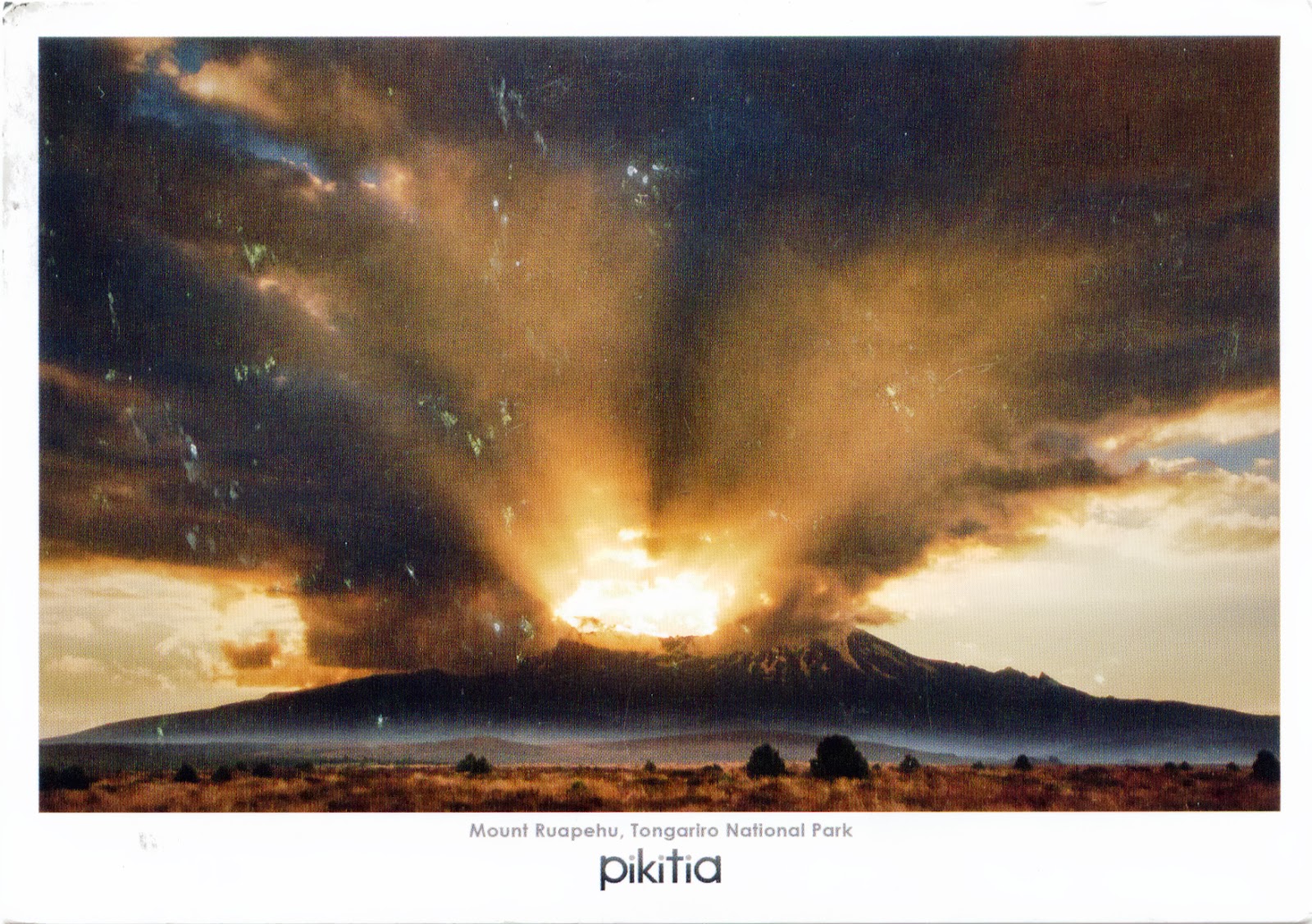
0793 NEW ZEALAND (North Island) - Tongariro National Park - Mount Ruapehu (UNESCO WHS)


In 1993 Tongariro National Park became the first property to be inscribed on the World Heritage List under the revised criteria describing cultural landscapes. The mountains at the heart of the park have cultural and religious significance for the Maori people and symbolize the spiritual links between this community and its environment. The park has active and extinct volcanoes, a diverse range of ecosystems and some spectacular landscapes. The park includes many towns around its boundary, and has in the centre the active volcanic mountains Ruapehu, Ngauruhoe, and Tongariro.

0792 MEXICO (México) - Pre-Hispanic City of Teotihuacan (UNESCO WHS)

0792 The Pyramid of the Sun in Teotihuacan

Located in the Basin of Mexico, 48km northeast of modern day Mexico City, Teotihuacan was established around 100 BC and continued to be built until about 250 AD. It may have lasted until sometime between the 7th and 8th centuries AD, and at its zenith, perhaps in the first half of the 1st millennium AD, was the largest city in the pre-Columbian Americas (with perhaps 150,000 inhabitants). Although it's a subject of debate whether Teotihuacan was the center of a state empire, its influence throughout Mesoamerica is well documented.

August 11, 2013

0790 SOUTH AFRICA - Shangaan warriors


The Tsonga people inhabit the southern coastal plain of Mozambique, parts of Zimbabwe and Swaziland, and Mpumalanga and Limpopo Province of South Africa. The Tsongas are a diverse population, generally including the Shangaan, Thonga, Tonga, and several smaller ethnic groups. Actually depending on the ethnic groups included in Tsongas can say that are between 4.5 and 13 million, so they are a minority in one country, but a majority in the subcontinent. Although many of them are Christians, many also adhere to their own traditional religion, which entails constant attention to the propitiation of ancestral spirits.

August 10, 2013

0788 & 0789 JAPAN (Kantō) - Sumida River Fireworks Festival


The first mention of a firework dates back to 7th century China, from where this custom has spread to other cultures. It seems that in Japan they reached in 17th century, and became popular due to the lords who resided in Edo, today’s Tokyo. In 1733, the eighth shogun, Tokugawa Yoshimune, organized the first such festival, Water God Festival, on the Sumida River, launching fireworks to honor the souls of the dead from the previous year, when some 1 million people had died of famine. According to Teruhiko Muto's Nihon no Hanabi no Ayumi (History of Fireworks in Japan), this river was preferred as place of holding the festival to avoid the summer heat. This became an annual event since 1810, under the name Ryōgoku Kawabiraki, which held on the last Saturday in July. The tradition continued nearly every year until 1920s, ceasing entirely during WWII and for several decades afterwards. Finally, in 1978, the tradition was reinstated, and continues to nowadays.


Now is known as Sumida River Fireworks Festival (Sumidagawa Hanabi Taikai), and follows the Japanese tradition of being an competition between rival pyrotechnic groups (previously organized into guilds). Each group tries to out-do the last, and the result is an incredible variety of fireworks, not just in different colors and patterns, but forming shapes as complicated as Doraemon, Pikachu, or Kanji.  A key characteristic of many Japanese fireworks is that they are spherical, being named according to their effects. Some of the names are flowers, including kiku (chrysanthemum), botan (tree peony) and yanagi (willow). Street vendors sell various drinks and food, and held various games, such as Kingyo-sukui (Goldfish scooping). Even today, men and women attend these events wearing the traditional Yukata (summer Kimono), or Jinbei (men only), collecting in large social circles of family or friends to sit picnic-like, eating and drinking, while watching the show.

August 9, 2013

0786 PHILIPPINES (Central Visayas) - Chocolate Hills Natural Monument (UNESCO WHS - Tentative List)


The Chocolate Hills are located in Bohol Province and is a rolling terrain of haycock hills, mounds of a generally conical and almost symmetrical shape. Estimated to be from 1,268 to about 1,776 individual mounds, spread over an area of more than 50 square km, these cone-shaped or dome-shaped hills are actually made of grass-covered limestone, that turns brown (like chocolate) during the dry season, hence the name. The domes vary in sizes from 30 to 50m high with the largest being 120m in height. They have been declared the country's third National Geological Monument and proposed for inclusion in the UNESCO World Heritage List in 2006, under the name Chocolate Hills Natural Monument.