Showing posts with label FRANCE (Auvergne-Rhône-Alpes). Show all posts

March 1, 2020

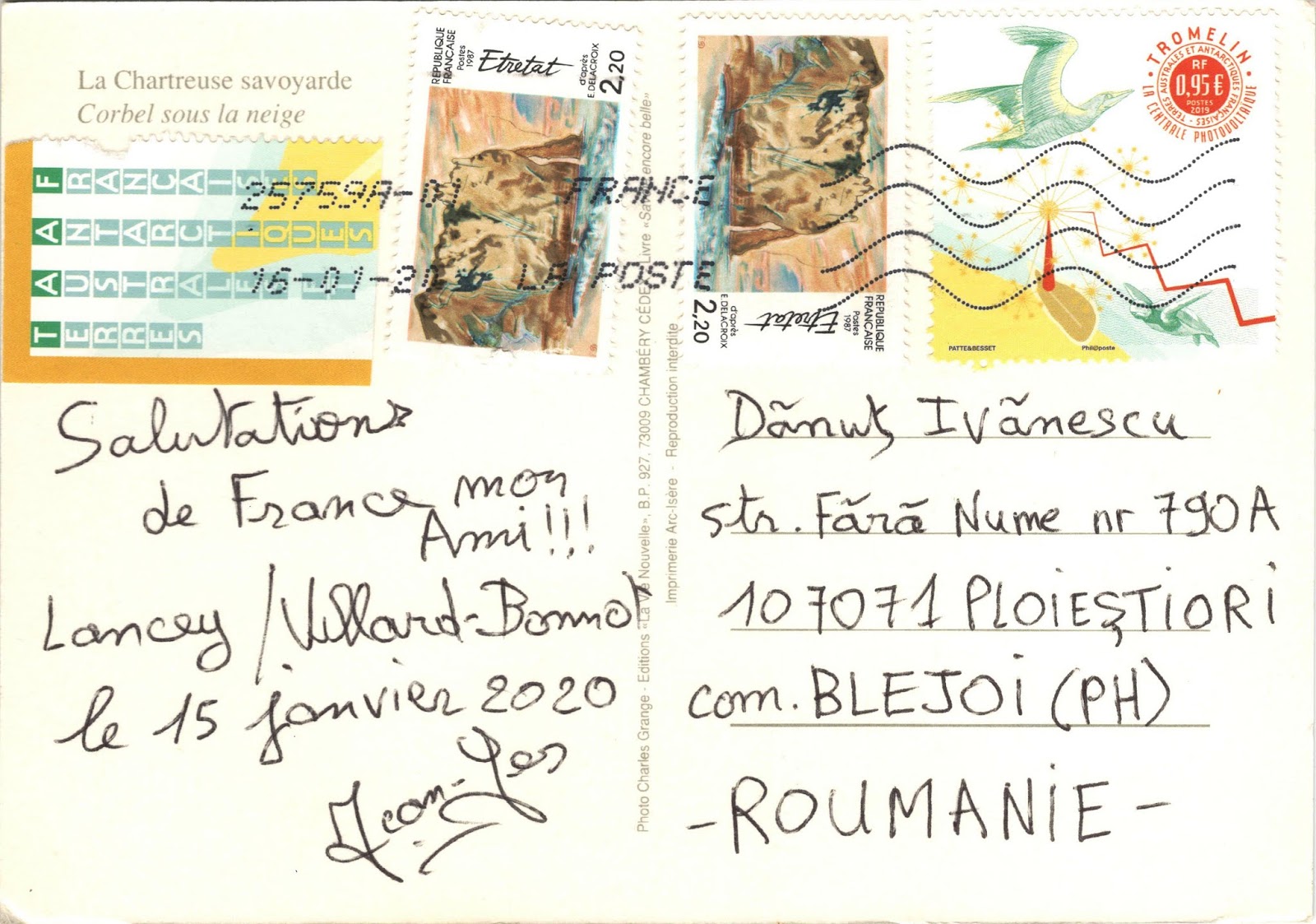
2221, 3388, 3411, 3428, 3443 FRANCE (Auvergne-Rhône-Alpes) - Chartreuse Mountains

2221 Chartreuse Mountains (1)

Located in southeastern France, the Chartreuse Mountains rises between Grenoble (south), Chambéry (north), Voiron and Saint-Laurent-du-Pont (west) and Grésivaudan Valley. It is the southernmost range in the Jura Mountains and belongs to the French Prealps. The monastic Carthusian Order takes its name from these mountains, where its first hermitage, Grande Chartreuse, was founded in 1084.

The desert road in Chartreuse
3428 The desert road in Chartreuse

Also derived from the mountain range's name is that of the alcoholic cordial Chartreuse produced by the monks since the 1740s, and of the chartreuse colour, named after the drink. The east flank falls abruptly almost 2,000m to the Isère valley, while to the west, the high ground falls away towards the Rhône valley. It is separated from the Vercors upland area to the south also by the Isère river, which swings round to the west at Grenoble on its way towards the Rhône.

Chartreuse Mountains
3388 Chartreuse Mountains (2)

Above the meadows in the valleys, wooded ridges rise up steeply towards steep limestone cliffs. Above these, may be found a hidden world of high altitude plateaus and valleys, vegetated with grassland and dwarf forest. The highest summit in the Chartreuse Mountains is Chamechaude (2,082 m), the third most prominent mountain (1,769m) in metropolitan France. Other important summits include Dent de Crolles (2,062m), Grand Som (2026m) and Mont Granier (1,933m).

3443 Chartreuse Mountains (4)

These are limestone mountains with rather large precipices. Mont Granier is known because in the year 1248, a mass of limestone resting on marls slid into the valley, causing a massive landslide that destroyed many villages and caused over a thousand casualties. This event created the sheer 700 m north face of the mountain.

3411 Chartreuse Mountains (3)

January 22, 2020

3340, 3355, 3381 FRANCE (Auvergne-Rhône-Alpes) - Uriage-les-Bains

3355

Posted on 08.01.2020, 14.01.2020, 22.01.2020
Located at 8 km from Grenoble, at the foot of the Belledonne massif, beneath the ski resort of Chamrousse, Uriage-les-Bains is a spa town attached to the communes of Saint-Martin-d'Uriage and Vaulnaveys-le-Haut. It was established during the Roman Empire. The Romans built baths to enjoy the anti-rheumatic properties of the springwater.

3381

Uriage thermal water contains sulphide and salt, and has a molecular concentration similar to that of human blood serum, which is unique in the world and allowed to be administered directly in intra-muscular injections. There are various curing techniques including showers, baths, hydromassages, applications of mud, filiform shower and aerosols.

3340 Uriage-les-Bains - The park dominates by the Château d'Uriage

The town is dominated by the Château d'Uriage, built in the 15th and 16th centuries, but it is likely that there are elements dating from the time of its construction by the Germans in the 13th century. The castle is made up of three massive main buildings, erected around a square courtyard, flanked by the corners of the round towers. The largest and tallest serving as a dungeon. In the late 1980s, it was transformed into a co-ownership of 50 flats, making it a private property.

December 10, 2019

2040, 2041, 2084, 2214, 2664, 2742, 2826, 3287 FRANCE (Auvergne-Rhône-Alpes) - Grenoble

2040 The map of Isère department and The Bastille in Grenoble

Posted on 16.11.2015, 29.11.2015, 14.01.2016, 23.07.2016, 06.09.2016, 15.10.2016, 10.12.2019
Located at the foot of the French Alps, where the river Drac joins the Isère, Grenoble is the capital city of the Isère department. The proximity of the mountains, as well as its size, has led to the city being known as the "Capital of the Alps". Its history goes back more than 2,000 years, at a time when it was a small Gallic village. While it gained in stature by becoming the capital of the Dauphiné in the 11th century, it remained for most of its history a modest parliamentary and garrison city on the borders of the Kingdom of France.

2742 Aerial view of Grenoble

The Bastille, an ancient series of fortifications at the south end of the Chartreuse mountain range, overlooking the city of Grenoble, was begun in the Middle Ages, but later years saw extensive additions, including a semi-underground defense network, credited as the most extensive example of early 18th-century fortifications in France, and then held an important strategic point on the Alpine frontier with the Kingdom of Savoy. A small garrison was maintained in the fort until 1940.

2826 The Palace of the Parliament of Dauphiné
 

The Palace of the Parliament of Dauphiné was constructed in Place Saint André around 1500 and extended in 1539. It was the location of the Parlement of Dauphiné until the French Revolution. It then became a courthouse until 2002. The left wing of the palace was extended in 1897. The front of the former seat of the nearby Dauphiné Parlement combines elements from a gothic chapel and a Renaissance façade. The building now belongs to the Isère Council (Conseil Général de l'Isère).

2041 Grenoble - The Isère's quai, the Bubbles,
the Marius Gontard Bridge, and Vercors Massif.

The Marius Gontard Bridge is historically the second Isère crossing site in Grenoble. The first stone bridge was built between 1621 and 1671. After much destruction and reconstruction, it was rebuilt in stone in 1839 and called the bridge of the Hospital. It carries since 1924 the same name as the street that continues, that of a General Counsel of Grenoble (1856-1923). With a total length of 73m, it has three spans, the central span, the longest, with a range of 27m.

2084 Grenoble - The Isère's quai on wintertime, and the Bubbles.

The first cable transport system was installed on the Bastille in 1875. Since 1934, the Bastille has been the destination of the Grenoble-Bastille Cable Car, known to locals as Les Bulles (the bubbles). It is one of the oldest urban cable cars in the world and runs all year round. The route takes the cars across the Isère and over the roofs of the old Saint Laurent quarter before passing over a bastion of the curtain wall of the fort and then over the Rabot and various successive fortifications before arriving at the upper station.


2214 Grésivaudan Valley - Funiculaire de Saint-Hilaire du Touvet,
villages with Belledone in background, Dent de Crolles, and the Bubbles.

Except for a few dozen houses on the slopes of the Bastille hill, Grenoble is exclusively built on the alluvial plain of the Isère and Drac rivers at an altitude of 214 metres. As a result, the city itself is extremely flat. Mountain sports are an important tourist attraction in summer and winter. Twenty large and small ski resorts surround the city, the nearest being Le Sappey-en-Chartreuse, which is about 15 minutes' drive away. Historically, both Grenoble and the surrounding areas were sites of heavy industry and mining.

2664 Grenoble
 

In 1987, Grenoble became the second French city to reintroduce trams, the first being the Nantes tramway. The current network is 35-kilometre long, and comprises five lines: lines A, B, C, D and E. Trams were first introduced to Grenoble in 1894, and this first generation tram system survived until 1952. The city is served by a total of 103 trams: the older 53, numbered from 2001 to 2053, are Alsthom TFS, whilst the newer 50, numbered from 6001 to 6050, are Alstom Citadis trams.

3287 Grenoble
 

February 4, 2018

3259 FRANCE (Auvergne-Rhône-Alpes) - Peasants of Ardeche in 1970's

3259 Joseph, Noemie and Celestin, paysans d'Ardeche in 1970's

Ardèche is a département in south-central France,  named after the River Ardèche. Picturesque, lush and wild, this département is a tapestry of ancient grey rock, verdant hills and thick forests. Heavily loaded with history and tradition, the sparsely populated Ardèche region is the perfect place to lose yourself in the simplest pleasures that rural France can offer, namely hearty regional fare and untamed beauty. The Ardèche is known in France as "chestnut country", and, for many locals, this anonymous wintertime ingredient holds iconic status. This explains its prominence in so many dishes and the region’s position as France’s leading producer.

March 2, 2017

2969 FRANCE (Auvergne-Rhône-Alpes) - Spiritual Center of Saint-Hugues in Biviers

2969 Biviers - Le Repos de Biviers in 1950s (the dining room )

Biviers is a commune located 10km northeast of Grenoble, at the foot of Mount Saint-Eynard, on a limestone scree located on the east side of the Chartreuse Mountains. Towards the southwest, Biviers faces the Belledonne range, in the Grésivaudan section of the Isère River valley. In Biviers is located Center Saint Hugues, "a house in the mountain where it is good to regain strength and meaning in God".

February 21, 2017

2957 FRANCE (Auvergne-Rhône-Alpes) - Valence, Drôme

2957 Valence, Drôme - Republic Square with
Hôtel de la Croix D'or (Hotel Golden Cross)
probably in 1960's

Situated on the left bank of the Rhône, about 100km south of Lyon, along the railway line that runs from Paris to Marseille, Valence is often referred to as "the door to the South of France", the local saying à Valence le Midi commence (at Valence the Midi begins) pays tribute to the city's southern culture. Inscribed on the list of flowery towns and villages of France, it is one of the seventeen municipalities of the Rhône-Alpes region to be labeled "four flowers" by the Concours des villes et villages fleuris, i.e. the maximum level.

February 17, 2017

2953 FRANCE (Auvergne-Rhône-Alpes) - Tamié Abbey


Situated in the Savoie region, on the eastern slopes of the Bauges mountain massif, at an altitude of 900 meters, the Cistercian abbey of Notre-Dame de Tamié is witness to a long history. Tamié Abbey was founded in 1132 by Saint Peter of Tarentaise, a monk from Bonnevaux Abbey, who was later to become the archbishop of Moûtiers. After a successful start in the golden age of the 12th Century, the abbey was adversely affected by prosperity, which led the monks away from the austere lifestyle on which the order was based.

February 12, 2017

2949 FRANCE (Auvergne-Rhône-Alpes) - Yvoire


Since ancient times, the upper valley of the Rhône and Lake Geneva (Lake Leman, in french) have formed a route through the Alps between Italy and France; the lake itself, with its varying winds, facilitates the transport of goods which are carried on lateen-rigged boats. Located at the tip of the Leman peninsula, Yvoire delimits the two main parts of the lake, the "petit lac" and the "grand lac". Its strategic position, didn't escape the notice of Count Amédée V the Great, who under took important fortifications from 1306, during the war between the Dauphiné and Savoy.

November 14, 2016

2866 FRANCE (Auvergne-Rhône-Alpes) - Parc des Oiseaux in Villars-les-Dombes

2866 Eurasian blue tit (Cyanistes caeruleus)
in Parc des Oiseaux in Villars-les-Dombes

The Parc des Oiseaux (Park of Birds) is an ornithological park, one of the oldest in France, located in Villars-les-Dombes, a commune situated in the heart of the area known as the Dombes, notable for its hundreds of lakes. Opened in 1970, it brings together a collection of more than 3,000 birds of 300 species from around the world. Visitors can observe the birds in 20 environments that recreate different landscapes on the planet, and the aviaries have been specially designed to allow visitors to get closer to the birds than ever before.

November 13, 2016

2864 FRANCE (Auvergne-Rhône-Alpes) - Nantua


Grew up around a Benedictine Monastery founded in 671 by St. Amand and the church of St Peter where the body of Charles the Bald was initially buried, Nantua has long been a transit town, crossed by the national road from Lyon to Geneva. It is located at the lake of the same name, and at the foot of a limestone cliff unstable under constant surveillance. In terms of gastronomy, the town has become famous for its sauce Nantua based on crayfish that mixes perfectly with the famous "quenelles de brochet" (pike dish).

November 10, 2016

2862 FRANCE (Auvergne-Rhône-Alpes) - Corbel


Corbel is a Savoyard commune, located in the Chartreuse massif, with a population of 138 inhabitants (2011). It is composed of 13 hamlets and rises at altitudes ranging from 470m, to the edge of the river Guiers Vif to the south, up to 1618m, to the summit of La Cochette to the north. Two mountains of the Chartreuse Mountains are located on the territory of the township: Roche Veyrand (1356 m) and Thivelet (1231m). The town of Corbel (845m), the center of the township, is located on the east side of Thivelet.

October 29, 2016

2845 FRANCE (Auvergne-Rhône-Alpes) - The exhibition "Space of Light"


The painter Patrice Giorda was born in 1952 in Lyon, where he lives and works until now. Spotted very early on, notably among the international selection at the XIIIth Paris Biennale in 1985, he has constantly made his personal mark as a painter in the classical sense. Although far removed from the avant-gardes that turn their backs on Painting, his figurative art nevertheless remains absolutely contemporary. His symbolic representation of man and nature goes beyond straightforward landscapes, scenes, portraits or still lives.