Showing posts with label GUYANA. Show all posts
March 29, 2016
2419 GUYANA - The Toco Toucan
More than 80% of Guyana is still covered by forests, ranging from dry evergreen and seasonal forests to montane and lowland evergreen rain forests. As a result, it has one of the highest levels of biodiversity in the world. The avifauna of Guyana include a total of 796 species, of which one is endemic and 94 are rare or accidental. Among them are eight species of toucans, passerine birds brightly marked, with enormous, colorful bills.
Locaţia:
Guyana
April 27, 2015
1545 GUYANA - Stabroek Market in Georgetown
Georgetown, the capital of Guyana, was established under the name Longchamps in 1782, during a brief occupation by the French of the Dutch colony of Demerara. The original name of the town was changed to Stabroek in 1784, after Nicholaas Geelvinck (1732-1787), Lord of Stabroek, the then President of the Dutch West India Company. The city's name changed again in 1812 when, under British rule, it became Georgetown. A ward of the city retains the name Stabroek, and also its main market, which has existed on or near its present location since the 18th century.
Etichete:
GUYANA,
stamps (complete series)
February 28, 2015
1022, 1472 GUYANA - The map and the flag of the country
![]() |
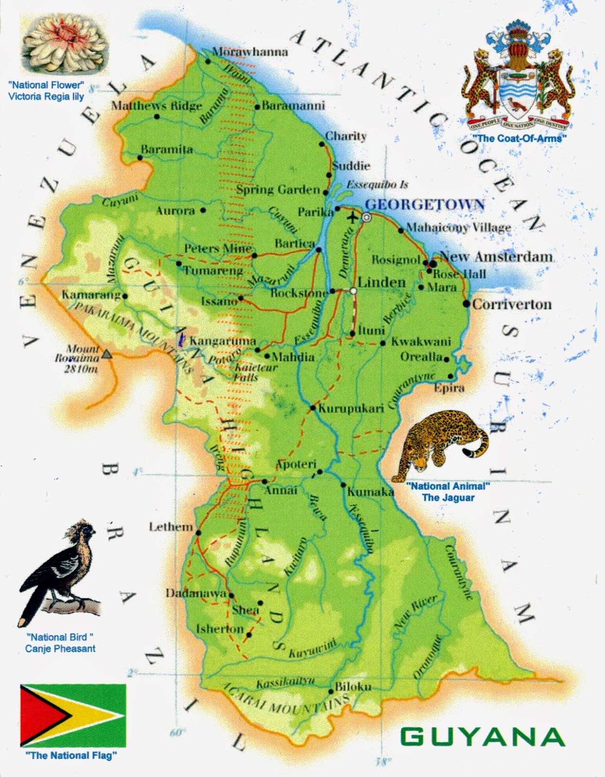
1472 - Guyana's map and national symbols |
Posted on 04.03.2014 and 28.02.2015
According to the Oxford English Dictionary, the name "Guyana" comes from an Amerindian word meaning "land of waters". Anyway, historically speaking, The Guianas (Las Guayanas in spanish) refers to a region in South America, north of the Amazon River and east of the Orinoco River, which includes French Guiana (an overseas department of France), Guyana (former British Guiana), Suriname (former Dutch Guiana), the Guayana Region in Venezuela (former Spanish Guyana), and Brazilian State of Amapá (former Portuguese Guiana). Guyana, officially the Co-operative Republic of Guyana, was originally colonized by the Netherlands, but became a British colony and remained so for over 200 years until it achieved independence in 1966, to become a republic in 1970.
![]() |
1022 - Guyana's flag |
It is the third-smallest independent state on the mainland of South America (after Uruguay and Suriname), and has a population of approximately 770,000 inhabitants, of which 90% reside on the narrow coastal strip. Racially and ethnically heterogeneous, with ethnic groups originating from India, Africa, Europe, and China, as well as indigenous or aboriginal peoples, its present population shares two common languages: English and Creole.
Etichete:
GUYANA,
Maps & flags,
stamps (complete series)
Locaţia:
Guyana
October 29, 2014
1321 GUYANA - Kaieteur Falls
Located on the Potaro River, in Kaieteur National Park, Kaieteur Falls were discovered in1870 by the British geologist Charles Barrington Brown. They have 226m high from its plunge over a sandstone and conglomerate cliff to the first break, and are among the most powerful waterfalls in the world, with an average flow rate of 663 cubic metres per second. In other words, this single drop waterfall is about four times higher than the Niagara Falls, and about twice the height of the Victoria Falls.
Etichete:
GUYANA,
Waterfalls
Locaţia:
Kaieteur Falls, Guyana
March 30, 2014
1038 GUYANA - St. Georges Anglican Cathedral (UNESCO WHS - Tentative List)
Located on Church Street in Georgetown, the capital city of Guyana, this Anglican cathedral, designed by Sir Arthur Blomfield, was consecrated in 1894. At the beginning, the architect Arthur Blomfield designed the plans of a cathedral in stone, with a central tower and two western towers, but these were rejected because of the weight and the expense. His subsequent plans for a wooden cathedral were accepted, a design that kept many of the salient features of his first plan, such as the central tower and the Latin cross formation of nave and transepts.
Subscribe to:
Posts (Atom)