Showing posts with label Mountains. Show all posts

March 9, 2020

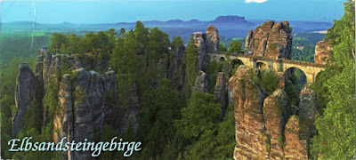
3453 GERMANY (Saxony) - Elbe Sandstone Mountains

Germany
3453 Elbe Sandstone Mountains - The Bastei bridge in Saxon Switzerland

The Elbe Sandstone Mountains is a mountain range straddling the border between Saxony in southeastern Germany and the North Bohemian region of the Czech Republic, with about three-quarters of the area lying on the German side. The river Elbe breaks through the mountain range in a steep and narrow valley. Their highest peak (723 m) is in Bohemia on the left bank of the river. The most striking characteristic of this deeply dissected rocky mountain range is the extraordinary variety of terrain within the smallest area.

March 1, 2020

2221, 3388, 3411, 3428, 3443 FRANCE (Auvergne-Rhône-Alpes) - Chartreuse Mountains

2221 Chartreuse Mountains (1)

Located in southeastern France, the Chartreuse Mountains rises between Grenoble (south), Chambéry (north), Voiron and Saint-Laurent-du-Pont (west) and Grésivaudan Valley. It is the southernmost range in the Jura Mountains and belongs to the French Prealps. The monastic Carthusian Order takes its name from these mountains, where its first hermitage, Grande Chartreuse, was founded in 1084.

The desert road in Chartreuse
3428 The desert road in Chartreuse

Also derived from the mountain range's name is that of the alcoholic cordial Chartreuse produced by the monks since the 1740s, and of the chartreuse colour, named after the drink. The east flank falls abruptly almost 2,000m to the Isère valley, while to the west, the high ground falls away towards the Rhône valley. It is separated from the Vercors upland area to the south also by the Isère river, which swings round to the west at Grenoble on its way towards the Rhône.

Chartreuse Mountains
3388 Chartreuse Mountains (2)

Above the meadows in the valleys, wooded ridges rise up steeply towards steep limestone cliffs. Above these, may be found a hidden world of high altitude plateaus and valleys, vegetated with grassland and dwarf forest. The highest summit in the Chartreuse Mountains is Chamechaude (2,082 m), the third most prominent mountain (1,769m) in metropolitan France. Other important summits include Dent de Crolles (2,062m), Grand Som (2026m) and Mont Granier (1,933m).

3443 Chartreuse Mountains (4)

These are limestone mountains with rather large precipices. Mont Granier is known because in the year 1248, a mass of limestone resting on marls slid into the valley, causing a massive landslide that destroyed many villages and caused over a thousand casualties. This event created the sheer 700 m north face of the mountain.

3411 Chartreuse Mountains (3)

February 2, 2020

0346, 2027, 2227, 2513, 3396, 3412 CANADA (Alberta) / UNITED STATES (Montana) - Waterton-Glacier International Peace Park (UNESCO WHS)

3396 Waterton-Glacier International Peace Park


The Waterton-Glacier International Peace Park is the union of the Waterton Lakes National Park in Canada and the Glacier National Park in the United States. Situated on the border between the two countries and offering outstanding scenery, the park is exceptionally rich in plant and mammal species as well as prairie, forest, and alpine and glacial features. It has a distinctive climate, physiographic setting, mountain-prairie interface, and tri-ocean hydrographical divide.

2027 CANADA - Waterton Lakes National Park -
Prince of Wales Hotel on the shore of Waterton Lake

Waterton Lakes National Park was named after Waterton Lake, in turn after the Victorian naturalist and conservationist Charles Waterton. The park contains 505 km2 of rugged mountains and wilderness, and ranges in elevation from 1,290m at the townsite to 2,910m at Mount Blakiston. Overlooked by the historic Prince of Wales Hotel, Waterton Lake is composed of two bodies of water, connected by a shallow channel known locally as the Bosporus.

2227 CANADA - Waterton Lakes National Park - Crypt Lake

Crypt Lake is a pristine alpine lake occupying a cirque that often has ice into August. Most of the area around the lake is covered in scree and/or snow, and hiking around the circumference of the lake requires approximately 45 minutes. The Crypt Lake Trail is one of the premium hikes in park. Wildlife can be spotted in the mountains towering above including mountain goat and bighorn sheep. The slopes along the Crypt Lake Trail serve as primary bear country. From Crypt Lake it is only a short walk to the edge of Crypt Falls with views over the valley below.

2513 CANADA - Waterton Lakes National Park - Cameron Falls

Located in Montana, Glacier National Park includes parts of three sub-ranges of the Rocky Mountains (Clark, Lewis, and Livingston Range), with at least 150 named mountain peaks over 2,400 m, over 130 named lakes (from a total of 700), more than 1,000 different species of plants and hundreds of species of animals. Of the estimated 150 glaciers which existed in the park in the mid-19th century, only 25 active glaciers remained by 2010, and is estimated that all the glaciers may disappear by 2020 if the current climate patterns persist.

0346 UNITED STATES - Glacier National Park -
Clements Mountain

Clements Mountain (2670m), located in the Lewis Range, which stands tall over Logan Pass and above the Hidden Lake Trail. The peak was named after Walter M. Clements who had worked to set up a treaty between the Native American tribe Blackfeet and the U.S. Government for the purchase of tribal lands east of the continental divide which became part of the park.

3412

Today, Blackfeet Indian Reservation borders the park in the east. Like other peaks in Glacier National Park, Clement Mountain exhibits a classic "Matterhorn" shape. Foreground is dominated by a plateau covered with a species of monkey-flowers, perhaps Lewis' monkeyflower (Mimulus lewisii), which is native to western North America, from Alaska to California and Colorado.

December 10, 2019

2040, 2041, 2084, 2214, 2664, 2742, 2826, 3287 FRANCE (Auvergne-Rhône-Alpes) - Grenoble

2040 The map of Isère department and The Bastille in Grenoble

Posted on 16.11.2015, 29.11.2015, 14.01.2016, 23.07.2016, 06.09.2016, 15.10.2016, 10.12.2019
Located at the foot of the French Alps, where the river Drac joins the Isère, Grenoble is the capital city of the Isère department. The proximity of the mountains, as well as its size, has led to the city being known as the "Capital of the Alps". Its history goes back more than 2,000 years, at a time when it was a small Gallic village. While it gained in stature by becoming the capital of the Dauphiné in the 11th century, it remained for most of its history a modest parliamentary and garrison city on the borders of the Kingdom of France.

2742 Aerial view of Grenoble

The Bastille, an ancient series of fortifications at the south end of the Chartreuse mountain range, overlooking the city of Grenoble, was begun in the Middle Ages, but later years saw extensive additions, including a semi-underground defense network, credited as the most extensive example of early 18th-century fortifications in France, and then held an important strategic point on the Alpine frontier with the Kingdom of Savoy. A small garrison was maintained in the fort until 1940.

2826 The Palace of the Parliament of Dauphiné
 

The Palace of the Parliament of Dauphiné was constructed in Place Saint André around 1500 and extended in 1539. It was the location of the Parlement of Dauphiné until the French Revolution. It then became a courthouse until 2002. The left wing of the palace was extended in 1897. The front of the former seat of the nearby Dauphiné Parlement combines elements from a gothic chapel and a Renaissance façade. The building now belongs to the Isère Council (Conseil Général de l'Isère).

2041 Grenoble - The Isère's quai, the Bubbles,
the Marius Gontard Bridge, and Vercors Massif.

The Marius Gontard Bridge is historically the second Isère crossing site in Grenoble. The first stone bridge was built between 1621 and 1671. After much destruction and reconstruction, it was rebuilt in stone in 1839 and called the bridge of the Hospital. It carries since 1924 the same name as the street that continues, that of a General Counsel of Grenoble (1856-1923). With a total length of 73m, it has three spans, the central span, the longest, with a range of 27m.

2084 Grenoble - The Isère's quai on wintertime, and the Bubbles.

The first cable transport system was installed on the Bastille in 1875. Since 1934, the Bastille has been the destination of the Grenoble-Bastille Cable Car, known to locals as Les Bulles (the bubbles). It is one of the oldest urban cable cars in the world and runs all year round. The route takes the cars across the Isère and over the roofs of the old Saint Laurent quarter before passing over a bastion of the curtain wall of the fort and then over the Rabot and various successive fortifications before arriving at the upper station.


2214 Grésivaudan Valley - Funiculaire de Saint-Hilaire du Touvet,
villages with Belledone in background, Dent de Crolles, and the Bubbles.

Except for a few dozen houses on the slopes of the Bastille hill, Grenoble is exclusively built on the alluvial plain of the Isère and Drac rivers at an altitude of 214 metres. As a result, the city itself is extremely flat. Mountain sports are an important tourist attraction in summer and winter. Twenty large and small ski resorts surround the city, the nearest being Le Sappey-en-Chartreuse, which is about 15 minutes' drive away. Historically, both Grenoble and the surrounding areas were sites of heavy industry and mining.

2664 Grenoble
 

In 1987, Grenoble became the second French city to reintroduce trams, the first being the Nantes tramway. The current network is 35-kilometre long, and comprises five lines: lines A, B, C, D and E. Trams were first introduced to Grenoble in 1894, and this first generation tram system survived until 1952. The city is served by a total of 103 trams: the older 53, numbered from 2001 to 2053, are Alsthom TFS, whilst the newer 50, numbered from 6001 to 6050, are Alstom Citadis trams.

3287 Grenoble
 

November 14, 2017

3197 RUSSIA (Arkhangelsk Oblast) - Hooker Island (Franz Josef Land)


Located within the Arctic Ocean, 360km north of Novaya Zemlya and 260km east of the Norwegian archipelago of Svalbard, Franz Josef Land constitutes the northernmost part of Russia's  Arkhangelsk Oblast. These 191 islands are 900km from the North Pole and 750km from the Yamal Peninsula, the closest point of the Eurasian mainland. At 81° north the archipelago experiences 141 annual days of midnight sun, from 12 April to 30 August.

August 13, 2017

3121 ROMANIA (Prahova / Braşov / Dâmboviţa) - Bucegi Mountains

3121 Panoramic view of Bucegi Mountains
in the village of Poiana Mărului, Braşov County

The Bucegi Mountains are located at the eastern extremity of the Southern Carpathians, extending between the Prahova Valley to the east and the Rucăr-Bran Corridor and the Ialomiţa Valley to the west, and are delimited to the North by the Bârsa Depression and to the South by the Sub Carpathians of Curvature. Being of a great structural and morphological complexity, the massif appears as a natural fortress, with an enclosure suspended from 1600-2500 m, supported by strong abrupts. The highest point of the massif is the Omu Peak (2514m).

June 24, 2017

2846, 3097 TANZANIA (Kilimanjaro) - Kilimanjaro National Park (UNESCO WHS)

3097 Mount Kilimanjaro (2)

Posted on 31.10.2016, 24.06.2017
Kilimanjaro National Park protects the largest free standing volcanic mass in the world and the highest mountain in Africa, rising 4877m above surrounding plains to 5895m at its peak. With its snow-capped peak, the Kilimanjaro is a superlative natural phenomenon, standing in isolation above the surrounding plains overlooking the savannah. It is composed of three volcanic cones: Kibo (5895m), Mawenzi (5,149m), and Shira (4,005m). Mawenzi and Shira are extinct, while Kibo is dormant and could erupt again.

2846 Mount Kilimanjaro (1)

The mountain has five main vegetation zones from the lowest to the highest point:  Lower slopes, montane forest, heath and moorland, alpine desert and summit. The whole mountain including the montane forest belt is very rich in species, in particular mammals, many of them endangered species. The mountain is drained by a network of rivers and streams, especially on the wetter and more heavily eroded southern side and especially above 1,200m. Below that altitude, increased evaporation and human water usage reduces the waterflows.

May 22, 2017

3061 INDIA (Himachal Pradesh) - Great Himalayan National Park Conservation Area (UNESCO WHS)

3061 Sar Pass Top as seen from Sar Pass

Great Himalayan National Park lies within the ecologically distinct Western Himalayas at the junction between two of the world’s major biogeographic realms, the Palearctic and Indomalayan Realms. It displays distinct broadleaf and conifer forest types forming mosaics of habitat across steep valley side landscapes, a compact, natural and biodiverse protected area system that includes 25 forest types and an associated rich assemblage of fauna species.